iancanton wrote:let's put neutrals on durham, to avoid someone having the north-east bonus from the drop. traditionally (before 1974), yorkshire was split into three ridings (east, north and west) plus the city of york. given most of the rest of the map, the three ridings plus york seems to be a more appropriate to divide yorkshire than the modern counties.
iancanton wrote:there is a something close to a four-way border where surrey, kent, east sussex and west sussex meet.
This definitely needs to be addressed... however - I don't think you should remove east/west of the sussex...
iancanton wrote:let's put neutrals on durham, to avoid someone having the north-east bonus from the drop.
This will reduce your (starting) territory count to 41 - which isn't such a good number as 42?
I'm not overly comfortable with Gloucestershire being in the "west midlands" group... It's always been in the "South West" in my lifetime...
Also - it's "Warwickshire" too
iancanton wrote:to satisfy those who want london included, it's possible to represent london stylistically (for example, a solid army circle) rather than with real boundaries.
Not sure this would work - because you're not including the other major connurbations such as "West Midlands" "South Gloucestershire" (Brizzle), "Manchester" & possibly "Tyneside" which are technically counties in themselves these days...
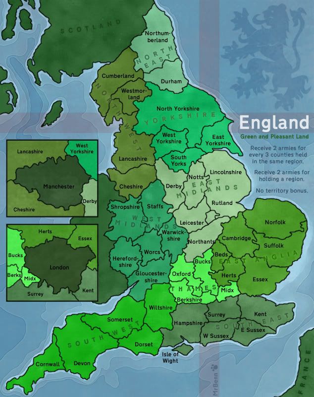
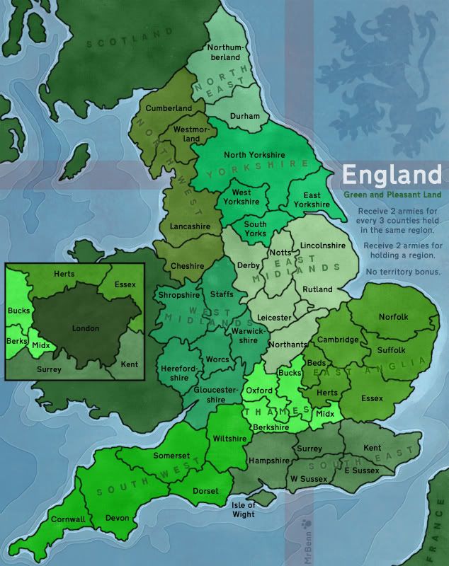
IMO this is the best graphical map I've seen here. Besides moving Berkshire down and to the left, Westmorland down, and possibly Rutland into Lincolns, I'd get the small up and get ready for a GFX stamp.
East & West Sussex will be staying as they are - primarily because this is the area of the country I call home!
With regards to the Kent/Sussex/Surrey "4-way" border... It's not my intention to allow West Sussex/Kent or East Sussex/Surrey to border. This seems fairly logical to me, but I'm not sure if it could be represented in any way, or whether I should tweak the borders a bit (which I don;t really want to do).
Gloucestershire... Like yeti, I think Gloucs looks and feels wrong in the West Midlands... I moved it there from its native South-West to prevent the SouthWest being a more favourable start, and harder to hold... any ideas?
North East - I'm reluctant to add neutral starts to the map... Yes, somebody might drop the pair, but it's only +2... any thoughts?
Yorkshire... 1 vote to merge West & South Yorkshire to create the Three Ridings.... 1 vote to keep them how they are... Personally I think it's good how it is
London... London... I've had an idea about London - I've added it as an inset in my next update... it looked a bit strange on its own, so I added Manchester too... I'm imagining that each will start with neutrals on, and will have a +1 autodeploy or something...discuss...
PB: 2661 | He's blue...If he were green he would die | No mod would be stupid enough to do that
I like that, and I'd keep W. and E. Yorks the way they are. And I think you should include a tiny tert … if only a symbol, to denote where Manchester and London are on the real map.
Oh, and Northants will probably fit better farther up in the territory.
Mind saying what (if any) grunge you added to the background?
The map looks excellent - fantastic artwork - the seas and shores are great and the lion.
And the map is a great for its geographical accuracy.
Or it was, until:
The M-place? (crosses himself)
"so I added M... too"?
I'll try to be objective - if the map is about the old counties then Manchester would be inconsistent. London could be argued for, although technically it used to be Middlesex, Surrey etc. (was the City of Westminster seperate maybe). Both are the diametrical opposite to the 'green and pleasant land' tag.
London has capital status etc. though so it is an understandable exception to the theme of the map (and maybe even worth +2 considering all the borders?)
If you do go for London, then surely if you're going for a small city as well then it would be right to have Birmingham before the M-place?
Seriously, why put M... in too? London is the capital and is one of the world's biggest cities. M... is just another city like Birmingham (and Leeds for that matter). The inset makes it look like the size of London.
Plus you'd get the Yorkshire tribe complaining if they are reduced to 3 terits and there's the M-place.
With Cheshire still there, the M... place, no Birmingham, Yorkshire down to 3, it would be a bit political, the working classes wouldn't be happy as a representation of their country. I'd say go modern or old school rather than ITV. It's just not cricket.
The rest of the map has had so much time put in to make it an accurate geographical representation of the old counties. That is a huge feature of the map. People from over the water wont realise, and possibly many southerners, but the northerner will.
Gloucestershire Tricky one, as you say, the bonuses wouldn't be right if it were where it should be. Maybe some tinkering with the bonuses might solve it, athough the bonus system is another good feature.
4-way borders Again, a tricky one. Having some sort of small image sprang to mind but I cant imagine it looking right - you might have no option but to alter slightly - the foundry would forgive you. Maybe someone will think of something though.
I'm guessing that DJ is from Salford or Bury or somewhere like that. I find myself, being a Stockport lad, agreeing with his sentiments about Manchester. If you need two city insets, and I dont think you do, then Brum would be the logical choice.
I'd keep Yorkshire as it is. As for Gloucestershire I dont know what to say...leave it as it is I suppose.
MrBenn wrote:North East - I'm reluctant to add neutral starts to the map... Yes, somebody might drop the pair, but it's only +2... any thoughts?
in a two-player game on such a small map, "only +2" on turn 1 probably gives victory to player 1. try coding the north-east counties as starting positions for two-player games only.
as for the question of london, i suspect that an england map would appear to have something missing if there was no mention of london. the county of london has existed ever since the creation of county councils in the 19th century, while all of the other metropolitan counties were created only in 1974. note that the inset covers greater london as it was after 1974, which is bigger than the county of london, as it includes nearly the whole of middlesex, while the main map omits london completely.
DJ Teflon wrote:Seriously, why put M... in too? London is the capital and is one of the world's biggest cities. M... is just another city like Birmingham
Birmingham is the countries second city - that would have to go in over Manchester.
Old County of London This map seems to show London pre-1974, as per iancanton's point: http://www.hill-bagging.co.uk/CountyTopsHistoric.php. There might be a better one out there though. WIth 4 bordering counties it might be easier to hold than the current version too.
Gloucestershire This map lumps together Thames with the South East and Gloucestershire with the South-West: http://www.picturesofengland.com/mapofengland/regions.html. I'm not sure if that would enable Gloucs to be SW and maintain gameplay balance- south-east would then be very big with the extra London bonus next door too.
Another idea might be to have a seperate 'West Country' region?
Anyway, it looks like all the talk is about the territories and borders - everyone is more than happy with the graphics and the gameplay / bonus system.
It seems like the public have spoken... I vaguely imagined that people would like to see a Northern City on the map, but I was proved very wrong... (if only it were this easy to obliterate undesired places in real life)... Whatchester?
PB: 2661 | He's blue...If he were green he would die | No mod would be stupid enough to do that
I don't like the London inset. Personally I'd rather see the map without it. I think it creates confusion. Perhaps London can be added to the map as a neutral territory or something and have a special bonus? Just an idea.
Also isn't the official anthem of England - "Land of Hope and Glory"? I think it's better than Green and Pleasant Land. Or else you can use the motto of England "Dieu et mon droit " which is actually in French. This is often seen on the coat of arms with the lion and unicorn.
Apart from that it's looking stunning although I would have preferred a traditional map in regards to gameplay like British Isles but I guess that's personal taste.
im confused with bonus definitions. now when im look north east he can worth only 2, and north west can worth 5? West midlands have potential bonuse of 8, and east anglia have same number of bonuses of 8 but have 5 defending territory and West midland have 4. Very confusing.
Yes, the bonuses do accumulate... so the total region bonuses would be as follows:
North East +2 (2 terrs) North West +4 (4 terrs) Yorkshire +4 (4 terrs) West Midlands +4 (5 terrs) East Midlands +6 (6 terrs) East Anglia +6 (6 terrs) Thames Valley +4 (5 terrs) South West +6 (6 terrs) South East +4 (5 terrs)
While the values may seem a fraction high, bear in mind that the map is incredibly open...
Since posting this, I've switched Gloucestershire into West Midlands (even though I don't really think it should go there) to balance the gameplay a little, which means the bonus areas for West Midlands and South West will change: West Midlands +5 (6 terrs) South West +4 (5 terrs)
The London inset was added in an attempt to to satisfy those who thought it should be on the map. I'm still not fully convinced it works - it feels a bit gimicky and out of place...
PB: 2661 | He's blue...If he were green he would die | No mod would be stupid enough to do that
If you decide the solution is a slight movement then it need only be tiny - if you look at Waterloo - the not-quite-junction of PO9, ZO4, P10 & P11 is a good example (centre-right of the map).
Alternatively, did something mark the border that could be a small image (e.g. a tree)?
i agree, when this map was first being created, i was thinking to myself, yay!!!!! another just plaine gameplay map, no special bonuses, no bombardments or anything, but with the insets of territories that are bonuses by themselves....i don't think its a good idea
i like the London insert, the only thing is that if you think about it logically Kent could not attack Midx if London is in the way but on the map it looks like it can. I would clear this up somehow if possible. Maybe i am wrong about this, but it is confusing to me.
tlane wrote:i like the London insert, the only thing is that if you think about it logically Kent could not attack Midx if London is in the way but on the map it looks like it can. I would clear this up somehow if possible. Maybe i am wrong about this, but it is confusing to me.
I guess the big question about the London insert is how important geographical accuracy and gameplay are to the cartographer. No London means 19th century england. London means 20th century (most of it) - although see previous discussion re.sizeof London pre-1974 (when the whole county landscape changed). The bonus for London would give the gameplay a slight twist, not a major change.
It looks like any of the 3 options would have different people supporting it.
However, if either of the insert options are selected (current insert or insert with old London county size) then it does seem that the main map would need amending to show London, as per thenobodies80's point.