Page 4 of 17

Posted:
Thu Mar 20, 2008 1:15 pmby grayhawke
bryguy wrote:grayhawke wrote:bryguy wrote:are those mountains.... or the tops of HUGE trees??? cause it looks more like leafs....
I quite liked the effect - could always change the legend to read
Impassable Terrain if it helps.

works for me
Consider it done!

Posted:
Fri Mar 21, 2008 10:58 pmby mibi
This looks like French In Action on an Apple IIGS, unfortunately, I don't think even Mireille could make it sexy.
Posted:
Sat Mar 22, 2008 2:32 amby Incandenza
Sir, for that Mireille reference, it is my distinct pleasure to award you the prize of one billion internets.
Relevance?
Posted:
Sat Mar 22, 2008 4:51 amby grayhawke
mibi wrote:This looks like French In Action on an Apple IIGS, unfortunately, I don't think even Mireille could make it sexy.
Incandenza wrote:Sir, for that Mireille reference, it is my distinct pleasure to award you the prize of one billion internets.
Have you read the guidelines? Please go and play somewhere else.
Re: Relevance?
Posted:
Sun Mar 23, 2008 9:41 pmby Incandenza
grayhawke wrote:mibi wrote:This looks like French In Action on an Apple IIGS, unfortunately, I don't think even Mireille could make it sexy.
Incandenza wrote:Sir, for that Mireille reference, it is my distinct pleasure to award you the prize of one billion internets.
Have you read the guidelines? Please go and play somewhere else.
Well, since you asked so nicely...
Visually you've made some strides, but the map is still not particularly attractive. The borders are pixilated as hell, some of the colors (especially cyan and yellow) are too bright, and the mountains.... well, let's just say the mountains leave a lot to be desired. The thing is that you're making a map of a period that has gorgeous extant maps, and there's nothing visually to this map that says "1648 HRE". Stylistically you really should have a look at some period maps and try and incorporate some of the details and textures thereof into your map.
The gameplay also seems to need a lot of work. Your bonus scheme obviously needs recalibration (for instance, the idea that eastern and western border states are worth the same bonus is ludicrous). Plus, if the cannon are supposed to represent areas of influence within the HRE, then why are three of them in prussia, hungary, and milan, the source of said influence? And more to the point, I fail to grasp the spanish influence concept as it applies to milan. In fact, I would be curious to know how historically accurate the areas of influence are. If they're not, but only there to heighten gameplay, that's fine, but then the onus is on you to show how the map requires the cannon...
Re: Relevance?
Posted:
Mon Mar 24, 2008 2:19 amby grayhawke
Incandenza wrote:Well, since you asked so nicely...
Thank you for taking the time to offer constructive criticism. I'll bear it in mind once the map gets to the foundry proper.
Re: Relevance?
Posted:
Sat Mar 29, 2008 6:18 amby Balsiefen
grayhawke wrote:Incandenza wrote:Well, since you asked so nicely...
Thank you for taking the time to offer constructive criticism. I'll bear it in mind once the map gets to the foundry proper.
I would bear it in mind now, He's made a good outline of pretty much everything which is stopping you getting into foundry proper.
Anyway, good luck.
Re: Holy Roman Empire+Bordering AD 1648 -V19 Pg.1 and 8 -20Mar08
Posted:
Sun Mar 30, 2008 2:55 pmby snufkin
I still think it´s ridiculous to make a map of an empire after it just lost the war.. The emperor only had proper control of Austria in 1648.
and besides that, I haven´t seen any professionally made map of the westphalian peace that look close to this.. It´s as if you´re not even trying to get it reasonably correct.
sort of like making a map of Nazi-Germany dated 1946
Re: Relevance?
Posted:
Sun Mar 30, 2008 3:12 pmby bryguy
Incandenza wrote:well, let's just say the mountains leave a lot to be desired.
mountains? i thought we decided they were giant trees....

Re: Holy Roman Empire+Bordering AD 1648 -V19 Pg.1 and 8 -20Mar08
Posted:
Sun Mar 30, 2008 5:02 pmby grayhawke
snufkin wrote:I still think it´s ridiculous to make a map of an empire after it just lost the war.. The emperor only had proper control of Austria in 1648.
and besides that, I haven´t seen any professionally made map of the westphalian peace that look close to this.. It´s as if you´re not even trying to get it reasonably correct.
sort of like making a map of Nazi-Germany dated 1946
Firstly, I see nothing ridiculous about the concept, nor understand why the loss of a war should make it so. Secondly it is not a map of the empire per se, but rather as I say in the first post "this map is based upon the boundaries set for mainland Europe following the Peace of Westphalia in 1648"; I found a certain amount of humour in the irony of having a Peace as the genesis of a battle-field. Lastly, I am not trying to create a map that could be used didactically, but one that might be a good basis for a game. As such it is perforce an abstraction from, and a simplification of, a complex reality.
Re: Relevance?
Posted:
Sun Mar 30, 2008 5:05 pmby grayhawke
bryguy wrote:Incandenza wrote:well, let's just say the mountains leave a lot to be desired.
mountains? i thought we decided they were giant trees....
Whatever they are I think we agreed they were Impassable!!

Re: Relevance?
Posted:
Sun Mar 30, 2008 5:08 pmby grayhawke
Balsiefen wrote:grayhawke wrote:Incandenza wrote:Well, since you asked so nicely...
Thank you for taking the time to offer constructive criticism. I'll bear it in mind once the map gets to the foundry proper.
I would bear it in mind now, He's made a good outline of pretty much everything which is stopping you getting into foundry proper.
Anyway, good luck.
Thanks, Version 20 should be posted shortly.
Re: Holy Roman Empire+Bordering AD 1648 -V19 Pg.1 and 8 -20Mar08
Posted:
Sun Mar 30, 2008 5:53 pmby snufkin
grayhawke wrote:it is not a map of the empire per se, but rather as I say in the first post "this map is based upon the boundaries set for mainland Europe following the Peace of Westphalia in 1648"; I found a certain amount of humour in the irony of having a Peace as the genesis of a battle-field.
If it´s meant to be ironic then fair enough I guess.. just a bit strange to start a map called
Holy Roman Empire and then choose a date when it was at its very weakest.
anarchy in europe, death of the holy empire, german small states, the peace of westphalia.. all would be less misleading titles imo
oh well I give up, you´re clearly not gonna make a 30 years war map and I dont know if you could pull it off anyway..
Re: Holy Roman Empire+Bordering AD 1648 -V19 Pg.1 and 8 -20Mar08
Posted:
Sun Mar 30, 2008 6:30 pmby grayhawke
snufkin wrote:grayhawke wrote:it is not a map of the empire per se, but rather as I say in the first post "this map is based upon the boundaries set for mainland Europe following the Peace of Westphalia in 1648"; I found a certain amount of humour in the irony of having a Peace as the genesis of a battle-field.
If it´s meant to be ironic then fair enough I guess.. just a bit strange to start a map called
Holy Roman Empire and then choose a date when it was at its very weakest.
anarchy in europe, death of the holy empire, german small states, the peace of westphalia.. all would be less misleading titles imo
oh well I give up, you´re clearly not gonna make a 30 years war map and I dont know if you could pull it off anyway..
Yes, I've had trouble with the title from the very start - I'd thought about
Peace of Westphalia (keeps the irony), but like your
anarchy in europe - perhaps
Anarchy in Europe AD 1648?
As for a map of the 30 years war - I might be tempted if I ever finish this one!

(one thing I've discovered, I'm not a natural cartographer

)
Re: Holy Roman Empire+Bordering AD 1648 -V19 Pg.1 and 8 -20Mar08
Posted:
Mon Mar 31, 2008 12:07 amby CatfishJohnson
sweet
Version 20
Posted:
Mon Mar 31, 2008 5:42 amby grayhawke
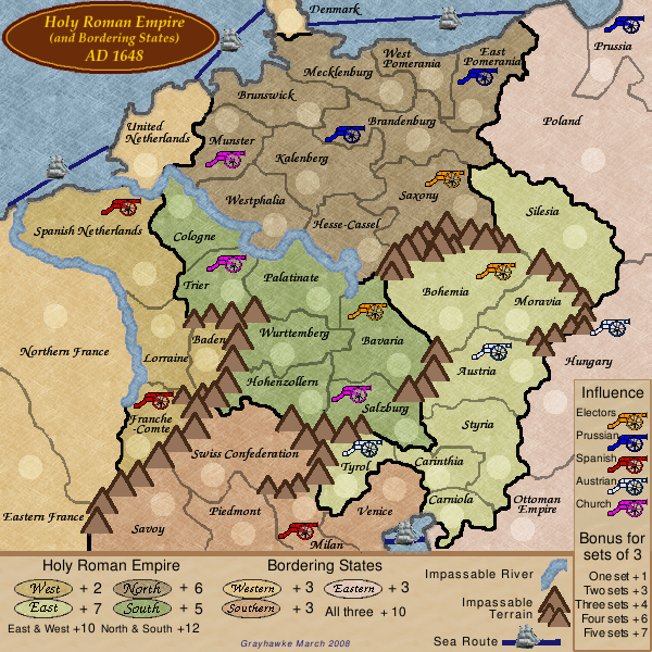
Revised colours to use shades found in historical maps.
Added a "paper" overlay.
Changed font used for names.
Tried another approach for the mountains.
Checked bonus scheme against spreadsheet values.
Re: Holy Roman Empire+Bordering AD 1648 -V20 Pg.1 and 7 -31Mar08
Posted:
Mon Mar 31, 2008 6:44 amby TaCktiX
This map is much easier on the eyes than earlier versions, and the mountains aren't making you think that a pinecone was shaken loose onto a sheet of paper. Good progress you've made on this map Grayhawke, can't wait to see it go further.
One small note, there is no explicit mention of what a "set" is, whether it's one of 3, one of 4, all of the same color, any of that. I know it's all of the same color, but Joe New Guy won't. Could you add a little more explanation on that?
Re: Holy Roman Empire+Bordering AD 1648 -V20 Pg.1 and 7 -31Mar08
Posted:
Mon Mar 31, 2008 7:32 amby Tieryn
TaCktiX wrote:This map is much easier on the eyes than earlier versions, and the mountains aren't making you think that a pinecone was shaken loose onto a sheet of paper. Good progress you've made on this map Grayhawke, can't wait to see it go further.
One small note, there is no explicit mention of what a "set" is, whether it's one of 3, one of 4, all of the same color, any of that. I know it's all of the same color, but Joe New Guy won't. Could you add a little more explanation on that?
It says bonus for sets of 3... and since no colour has more than 3...? I assume that's what it means? ... if they were different colours it'd hardly be a set would it? that's my Joe New Guy look at this map having never seen it before... I think it explains fine...
This is looking good, connection from denmark to poland is pretty pixellated. as are most of the water lines... I'm having trouble working out which territory is which space... which is western empire and western bordering states? the colours between northern france/franche-comte are too similar for me to distinguish the legend. Perhaps it might be worth having some specially territory texture for the holy roman empire, to separate it graphically from the bordering states... Then similar colours could be used...
Or swap the colours, so the west of the empire is one colour, but the east of the bordering states is the similar close colour... The west/east divide will explain when close colour matching will be hard.
Re: Holy Roman Empire+Bordering AD 1648 -V20 Pg.1 and 7 -31Mar08
Posted:
Mon Mar 31, 2008 10:47 amby TaCktiX
Tieryn wrote:It says bonus for sets of 3... and since no colour has more than 3...? I assume that's what it means? ... if they were different colours it'd hardly be a set would it? that's my Joe New Guy look at this map having never seen it before... I think it explains fine...
Congratulations me for missing words. Sorry, my bad on that one.
Version 21
Posted:
Mon Mar 31, 2008 10:46 pmby grayhawke
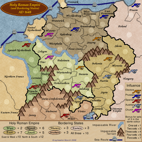
Swapped colours within the HRE divisions.
Added text to clarify the concept of a
set.
Updated the Sea Routes.
Re: Holy Roman Empire+Bordering AD 1648 -V21 Pg.1 and 7 -01Apr08
Posted:
Tue Apr 01, 2008 12:34 pmby CatfishJohnson
cant wait to play it broski
Support - thank you.
Posted:
Tue Apr 01, 2008 9:38 pmby grayhawke
CatfishJohnson wrote:cant wait to play it broski
Thanks for the support - all seven of you that have expressed interest in the idea and in playing this map.
And thank you also to the many more who have taken the time to comment on the graphics and the gameplay.
Re: Holy Roman Empire+Bordering AD 1648 -V21 Pg.1 and 7 -01Apr08
Posted:
Wed Apr 02, 2008 12:16 pmby Ogrecrusher
This is looking much better than when I last poked my nose in this thread, now it looks like a map that will eventually make it!
Now, comments.
As you probably know, many of the borders still look very crunchy and pixellated. This is worst on the black borders but also a problem on others if you look closely. The cannons suffer from this too.
The Savoy - Eastern France border is very straight. Unless this is based on a historical border, I'd add some wiggles.
The sea routes are very straight too, maybe you've done this to avoid the pixellation present on the other borders, but they don't look very real. What if you just used a wiggling row of dots, the quenched Scotland map is a great example of this style. Another reason to do this is the Venice - Ottoman route, the ship looks huge there! On the other routes the ships look ok, but that route is so small that the scale size of the ship looks silly.
Munster should be Münster (Thanks Europa Universalis III!), and there may be other umlauts missing that I'm not aware of.
The Mountains are much better than before, but to me they still look a bit out of place, I think it's the straight lines again. Maybe some nice curvy hills are needed. Or Snow capped peaks around the Alps? You could have different mountains in different places on the map.
The continent colours should be more distinctive. In general I think the colour scheme is good, but the colours are very similar, and it takes someworking out to see which continent is which. North, East and West are distinctive, but all the others have a very similar colour scheme (I have good colour vision, the problem may be worse for colourblind people).
There are by my count 2 dead end territories on this map that only border one other territory: Prussia and Baden. It's usually seen as a good idea to minimise the number of dead ends. I suggest removing the mountains and connect Baden to Franche-Comte maybe. No idea about Prussia though. Still, it's not a massive problem having them, just desirable not to.
I think that's all for now. Hope you find my thoughts useful, I think this is the most comments I've ever posted!
Ogrecrusher
Re: Holy Roman Empire+Bordering AD 1648 -V21 Pg.1 and 7 -01Apr08
Posted:
Wed Apr 02, 2008 10:48 pmby mibi
This map looks like a mash-up of France and the Oregon Trail. Although the colors are the best so far.
Re: Holy Roman Empire+Bordering AD 1648 -V21 Pg.1 and 7 -01Apr08
Posted:
Thu Apr 03, 2008 9:04 pmby grayhawke
Ogrecrusher wrote:This is looking much better than when I last poked my nose in this thread, now it looks like a map that will eventually make it!
Now, comments.
...
I think that's all for now. Hope you find my thoughts useful, I think this is the most comments I've ever posted!
Ogrecrusher
thanks for the encouragement and for the very useful comments.
1. Borders and Cannons - yes I know they need work - not sure whether to keep the borders as distinct lines or re-try the dark-and-fading border approach.
2. I'll revamp the sea routes - might try using a row of very small ships.
3. I've seen the spellings of Münster, Muenster and Munster used in various articles and maps. I decided to use Munster as being easiest.
4. I find the simplicity of the current mountains appealing. I doubt I'll change them - but am open to persuasion.
5. I'll tweak the continent colours a wee bit as suggested.
6. I'll open up Baden as suggested, and may change the Denmark-Poland sea route to Denmark-Prussia.