Page 4 of 11

Re: British India - map and question, page 5

PostPosted: Sun Nov 23, 2008 2:11 pm
by oaktown
captainwalrus wrote:Also. The bonus fot the bombay-calcatta line shoucld be 3 not 4.

Really? Six territories, all of which are borders... if I was going to change it I'd say make it even higher, but I think it's in line with the others.

Thanks for stopping in, Ian... I'll get back on this map after (if) I've come up with a plan for the revamp competition.

Re: British India - map and question, page 5

PostPosted: Sun Nov 23, 2008 7:07 pm
by captainwalrus
My mistake, I was looking at the wrong rail.

Re: British India - map and question, page 5

PostPosted: Sat Dec 06, 2008 8:44 pm
by oaktown
Click image to enlarge.
image

Alright, so nobody likes the island connection idea. That was the most recent gameplay suggestion - anything else?

Changes to this version are mostly visual, though I did increase the overall size of the playing area so that the small map will work.

"Indian Empire" we will now call this map, so the map will be alphabetized under "I" as pointed out on the last page.

Mountains are very heavy looking all of a sudden... I'll see to that.

Re: Indian Empire (was British India) page 6

PostPosted: Sat Dec 06, 2008 9:55 pm
by The Neon Peon
Why did you include Bangladesh as part of India? I thought it broke away by that time... or I might need to revisit my history notes.

Re: Indian Empire (was British India) page 6

PostPosted: Sat Dec 06, 2008 11:00 pm
by oaktown
The Neon Peon wrote:Why did you include Bangladesh as part of India? I thought it broke away by that time... or I might need to revisit my history notes.

I believe bangladesh was a part of british india right up until the brits split up the whole lot in 1947.

Re: Indian Empire (was British India) page 6

PostPosted: Sun Dec 07, 2008 10:00 am
by The Neon Peon
Just wondering... could you make a series of maps in this style? like the Japan and Brazil maps. Just old maps of the world in that book of yours.

Re: Indian Empire (was British India) page 6

PostPosted: Sun Dec 07, 2008 11:28 am
by oaktown
The Neon Peon wrote:Just wondering... could you make a series of maps in this style? like the Japan and Brazil maps. Just old maps of the world in that book of yours.

I certainly could - and between my Brazil revamp entry, a short-lived attempt at Japan, and this, you could say I already have made a series! But in the end, it would be a bit boring both for me and for the site. I think it's a nice look, but I'm not sure it's that nice.

Re: Indian Empire (was British India) page 6

PostPosted: Mon Dec 08, 2008 11:42 pm
by InkL0sed
If you hold the Madras Presidency + the Madras to Bombay rail line, you get a +9. That seems excessive to me, considering you'd only have 4 borders.

Re: Indian Empire (was British India) page 6

PostPosted: Tue Dec 09, 2008 12:09 am
by oaktown
InkL0sed wrote:If you hold the Madras Presidency + the Madras to Bombay rail line, you get a +9. That seems excessive to me, considering you'd only have 4 borders.

Yes, I'd agree... the trouble is which to knock down, the rail line or the region bonus? I think I'd lean toward the making the rail line a +2, because Presidency will be a bitch to hold if somebody else holds the Bombay Presidency and is dug in.

If we drop the Madras-Bombay line, it may be appropriate to also drop the Delhi-Calcutta line to +2, and possibly up the Bangal Pres bonus to +8 to preserve the big take for holding both.

Another solution would be opening up another border for Madras Presidency somewhere... I'll look into that.

Re: Indian Empire (was British India) page 6

PostPosted: Tue Dec 09, 2008 2:18 am
by oaktown
Click image to enlarge.
image


What's new: changed bonuses as noted above; added a mountain range in Farther India which makes that region a bit easier to hold with just two border territories; changed a territory name; added some decorative elements.

Re: Indian Empire (was British India) page 6

PostPosted: Tue Dec 09, 2008 4:02 am
by yeti_c
Are Nepal and Bhotan playable territories? (This is just a query - you don't need to make the map any clearer - as it'll be obvious when there are army numbers on them)

C.

Re: Indian Empire (was British India) page 6

PostPosted: Tue Dec 09, 2008 4:21 am
by n_p123
oaktown wrote:
The Neon Peon wrote:Why did you include Bangladesh as part of India? I thought it broke away by that time... or I might need to revisit my history notes.

I believe bangladesh was a part of british india right up until the brits split up the whole lot in 1947.

yup thats correct.

i am an indian and i must say i like it a lot :D
ya i agree something needs to be done about those excessive bonus we get by holding the railway and region bonus.

i say think about decreasing all region bonus by one.

Re: Indian Empire (was British India) page 6

PostPosted: Thu Dec 11, 2008 4:05 pm
by TaCktiX
Small nitpick, but the glow around the bonus names in the bottom left seem like they are uneven. More specifically, the Bengal and Madras Presidencies seem to barely be there, but the Bombay Presidency is exploding out there. They may be the same numerical glow, but I'd suggest altering them to look the same to the untrained eye. The default Screen filter vs. the book might be the root cause.

Re: Indian Empire (was British India) page 6

PostPosted: Mon Dec 15, 2008 12:12 am
by a.sub
well done! but i hav a question, where did u get that book from? it looks nice, and fits well in.

Re: Indian Empire (was British India) page 6

PostPosted: Mon Dec 15, 2008 1:07 am
by oaktown
a.sub wrote:well done! but i hav a question, where did u get that book from? it looks nice, and fits well in.

I began with an old map image I found online, but I've changed it so much (altered the depth and light source, changed the color, took out "pages" to make it take up fewer pixels, etc) that there isn't much left of the source image at this point.

Anybody else agree that the above legend lines stand out too much? My color-blindness is well-documented, so to me they look pretty good.

Re: Indian Empire (was British India) page 6

PostPosted: Mon Dec 15, 2008 10:06 pm
by The Neon Peon
oaktown wrote:Anybody else agree that the above legend lines stand out too much? My color-blindness is well-documented, so to me they look pretty good.

Not sure which legend you are talking about, but the only problems I see with either of them is that the Bombay Bonus in the legend has too much of a glow. It is larger than the others.

Re: Indian Empire (was British India) page 6

PostPosted: Tue Dec 16, 2008 1:52 am
by a.sub
The Neon Peon wrote:
oaktown wrote:Anybody else agree that the above legend lines stand out too much? My color-blindness is well-documented, so to me they look pretty good.

Not sure which legend you are talking about, but the only problems I see with either of them is that the Bombay Bonus in the legend has too much of a glow. It is larger than the others.

also i think the central provinces are too dull, and a bit harder to see, although that could just be the fact that im new to map making, and hav no idea about what im talking about :D

Re: Indian Empire (was British India) page 6

PostPosted: Tue Dec 16, 2008 5:31 pm
by Ruben Cassar
Impressive map oak...but I don't like the name Indian Empire as India was a British dominion not an empire as far as I know...

Re: Indian Empire (was British India) page 6

PostPosted: Thu Dec 18, 2008 5:29 am
by iancanton
it was called the indian empire on old british maps (unsure about non-british maps) and queen victoria had the title empress of india.

http://www.philatelicdatabase.com/wp-co ... e-1935.jpg
http://en.wikipedia.org/wiki/Empress_of ... h_monarchs

ian. :)

Re: Indian Empire (was British India) page 6

PostPosted: Sun Dec 28, 2008 8:33 pm
by LED ZEPPELINER
this map is really cool, good idea with the railways, i can't wait to play it :lol: =D> :shock: 8-) :mrgreen:

Re: Indian Empire (was British India) page 6

PostPosted: Sat Jan 03, 2009 5:06 pm
by a.sub
since u included Bangladesh, u also need to include Pakistan because that was part of the empire
http://en.wikipedia.org/wiki/British_India

Re: Indian Empire (was British India) page 6

PostPosted: Sat Jan 03, 2009 5:35 pm
by a.sub
and farther india should be called Myanmar

Re: Indian Empire (was British India) page 6

PostPosted: Sun Jan 04, 2009 12:28 pm
by oaktown
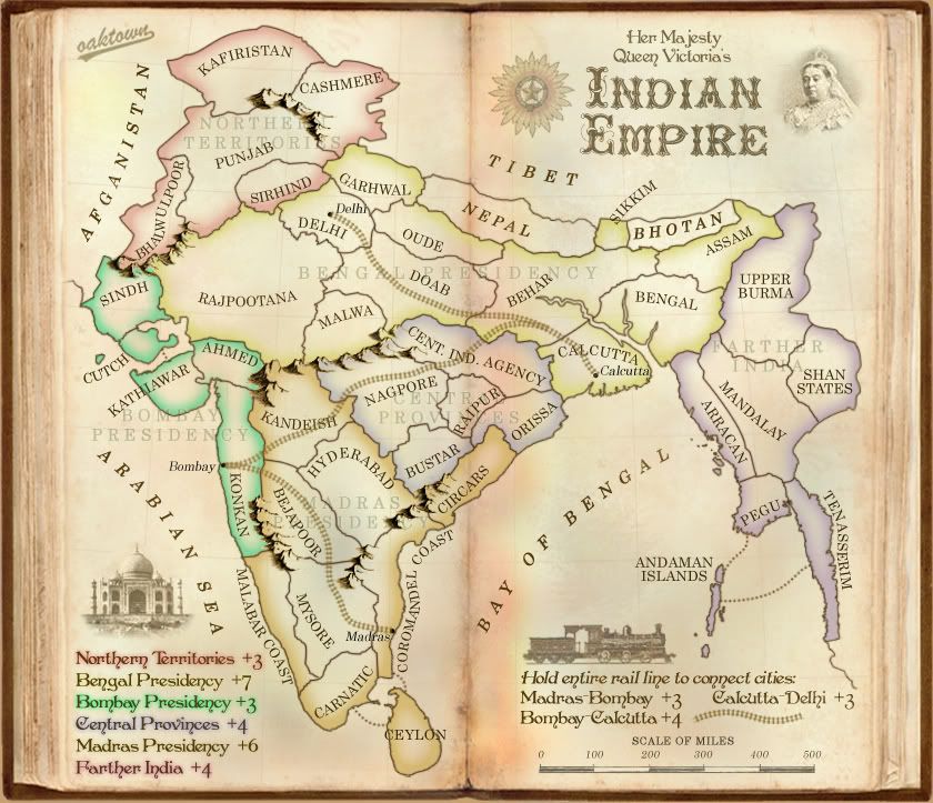
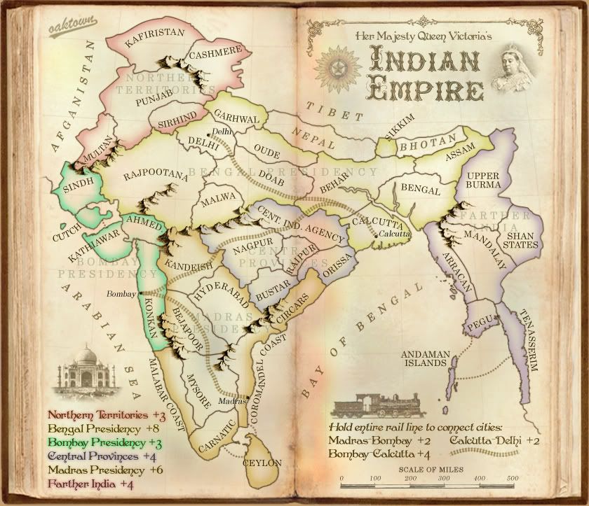
a.sub wrote:and farther india should be called Myanmar

A more appropriate alternative name for the eastern part of the map would be Burma, since this is a map from the British point of view and the British would not have referred to the area as Myanmar in/around the 1870s. I have seen the region of the British Empire east of the subcontinent referred to on maps of the time as both "Farther India" and "Burma," and while Burma may be more accurate I liked Farther India because it seemed more antiquated. I could live with calling it Burma if folks like that better, but Myanmar would be inappropriate for a British map of this era.

a.sub wrote:since u included Bangladesh, u also need to include Pakistan because that was part of the empire
http://en.wikipedia.org/wiki/British_India

The region in question here is the far-western region referred to on old British maps as Baluchistan/Baloochistan/Balochistan. I find that the region is included in some 19th Century maps, excluded in others. From what little I've read of the history of the area, the princely states there came under british control bit by bit via a series of treaties in the 1870s, and in many cases the princes continued to control them with british advisors.

Here's one map that as late as 1893 that does NOT include the regions among the possessions of the Indian Empire...
Click image to enlarge.
image


Like I said, some maps show Baluchistan, some do not. That being the case, I feel that leaving the area off the map is better both visually and for gameplay purposes. Visually it extends the map another 70 or so pixels to the west, which means dead space. Historically, Baluchistan would never have been a part of the Bombay Presidency, to which is would be connected, and play-wise it would create an infortunate western connection in the west between Bombay Presidency and the Northern Territories.

What I would rather do is add a non-playing border in the west and add the Balochistan name, paying tribute to the region's existence yet NOT including it for play, as we have done with Nepal and Bhotan.

Re: Indian Empire (was British India) page 6

PostPosted: Mon Jan 05, 2009 1:38 am
by a.sub
oops my bad ur right :oops:

Re: Indian Empire (was British India) page 6

PostPosted: Wed Jan 14, 2009 8:44 pm
by captainwalrus
What is left to be done on this? It doesn't have that many posts but I'm having trouble finding problems. I'd say this could be on the final forge very soon.