- Click image to enlarge.
Thailand
Moderator: Cartographers
Re: Thailand (draft2)
![]() by natty dread on Tue Sep 07, 2010 12:01 pm
by natty dread on Tue Sep 07, 2010 12:01 pm
griff, you should know by now to post updates to both ends of the thread... it's annoying to jump back to pg1 

-

 natty dread
- Posts: 12877
- Joined: Fri Feb 08, 2008 8:58 pm
- Location: just plain fucked


Re: Thailand (draft2)
![]() by natty dread on Tue Sep 07, 2010 12:03 pm
by natty dread on Tue Sep 07, 2010 12:03 pm
Anyway, I think you will have problems with the small version... there are a few territories that look too small to be legible in the small version...
A good trick is trying to fit army numbers that are 133% the normal size on the map. This way you'll know if the army numbers will fit once the map is shrunk into 3/4 the size.
A good trick is trying to fit army numbers that are 133% the normal size on the map. This way you'll know if the army numbers will fit once the map is shrunk into 3/4 the size.
-
natty dread
- Posts: 12877
- Joined: Fri Feb 08, 2008 8:58 pm
- Location: just plain fucked
Re: Thailand (draft2)
![]() by grifftron on Tue Sep 07, 2010 12:06 pm
by grifftron on Tue Sep 07, 2010 12:06 pm
natty_dread wrote:Anyway, I think you will have problems with the small version... there are a few territories that look too small to be legible in the small version...
A good trick is trying to fit army numbers that are 133% the normal size on the map. This way you'll know if the army numbers will fit once the map is shrunk into 3/4 the size.
which terts? Because i have seen CC maps that have been quenched where the digis don't even fit in the tert / or overlap the tert boarders... If this really is an issue i could resize the map now to an 800x800 or a little larger, i am at 800hx600w at the moment...
just an example of a CC map and over lapping boarders with digi circles.
so is this gonna be an issue or what? cuz WWII_Europe seems to work just fine with its tiny terts.
-griff

-

grifftron
- SoC Training Adviser
- Posts: 3280
- Joined: Thu Jul 09, 2009 6:11 am


Re: Thailand (draft)
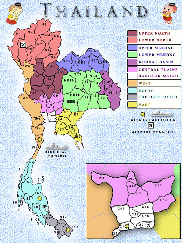
![]() by FarangDemon on Tue Sep 07, 2010 12:16 pm
by FarangDemon on Tue Sep 07, 2010 12:16 pm
Industrial Helix wrote:
Gameplay wise, this map looks like a nightmare to play. There is very little by way of choke points and if I were to play it, I'd feel like I have no strategy other than chance. I'd say add some impassables and fudge some of the borders to make the Bangkok region more important... see the Mexico draft so see what I mean.
Good point - we're planning to add mountains and/or rivers to choke this biatch up.
Industrial Helix wrote:The ship... I think I like it. I'd rather see more reliance on the ship to round out gameplay rather than airports.
You gotta like it - it's the smallest aircraft carrier in the world.
If possible we'll only have one flight - Bangkok to Chiang Mai.
Guess we could consider a railway instead - there is a north south line going all the way up and down the country.
I love rail maps but I was concerned it could get too complicated.
We're already planning on adding some additional bonus icons to various provinces to represent Thai culture/geography/economy which accumulate to provide bonuses in a simple manner.
Industrial Helix wrote:The names, South, North, South West ect. ought to go. Put something Thai in there.
We will use Thai names unless they are too long.
- Click image to enlarge.

"He came dancin across the water.... FarangDemon, FarangDemon.... mmmhh....what a killer..."
-
FarangDemon
- Posts: 700
- Joined: Wed Apr 23, 2008 1:36 am


Re: Thailand (draft2)
![]() by danfrank on Tue Sep 07, 2010 12:24 pm
by danfrank on Tue Sep 07, 2010 12:24 pm
grifftron wrote:natty_dread wrote:Anyway, I think you will have problems with the small version... there are a few territories that look too small to be legible in the small version...
A good trick is trying to fit army numbers that are 133% the normal size on the map. This way you'll know if the army numbers will fit once the map is shrunk into 3/4 the size.
which terts? Because i have seen CC maps that have been quenched where the digis don't even fit in the tert / or overlap the tert boarders... If this really is an issue i could resize the map now to an 800x800 or a little larger, i am at 800hx600w at the moment...
just an example of a CC map and over lapping boarders with digi circles.
so is this gonna be an issue or what? cuz WWII_Europe seems to work just fine with its tiny terts.
-griff
The map you are refering too is way over 100 terts ... Without counting this map looks to be around 60.. I like the idea of a thailand map .. But possibly you should postion the map in the center making it the main focal point which would give you room to expand the areas in question and then put the bonus boxes and other areas of explanation around the map..
-
danfrank
- Posts: 611
- Joined: Mon Dec 24, 2007 1:19 am


Re: Thailand (draft2)
![]() by natty dread on Tue Sep 07, 2010 1:18 pm
by natty dread on Tue Sep 07, 2010 1:18 pm
Numbers can overlap borders, but not in a way that important features (territory connections and such) are covered. Also it should be avoided when possible.
-
natty dread
- Posts: 12877
- Joined: Fri Feb 08, 2008 8:58 pm
- Location: just plain fucked
Re: Thailand (draft3)
![]() by grifftron on Wed Sep 08, 2010 12:42 am
by grifftron on Wed Sep 08, 2010 12:42 am
Re sized (W=+30% / H=+10%) also centered the map as suggested and got rid of the poor cute kids. I really just want to make sure these troop counts with fit before moving on... RedB suggested maybe making some of the small terts into 1 if this re sized version is not big enough... i am at 800x800 now.
The big circles are just to show how the digis would fit, they will be removed if so and so are pleased...
-griff
The big circles are just to show how the digis would fit, they will be removed if so and so are pleased...
-griff
-
grifftron
- SoC Training Adviser
- Posts: 3280
- Joined: Thu Jul 09, 2009 6:11 am
Re: Thailand (draft3)
![]() by The Bison King on Wed Sep 08, 2010 10:06 am
by The Bison King on Wed Sep 08, 2010 10:06 am
Whose this weirdo? I miss the boys.

-

The Bison King
- Posts: 1957
- Joined: Thu Aug 27, 2009 5:06 pm
- Location: the Mid-Westeros


Re: Thailand (draft3)
![]() by grifftron on Wed Sep 08, 2010 10:10 am
by grifftron on Wed Sep 08, 2010 10:10 am
The Bison King wrote:Whose this weirdo? I miss the boys.
Your joking right? One of the most famous pictures in Thailand, you might see this picture 4 out of every 5 houses you go into... and would for sure see this mans picture in every Thai person's house here in the land of Thai's... except for in Farang's house.. not sure about that...
The peoples king.
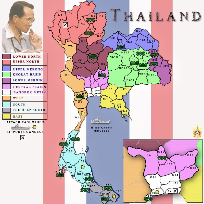
We merged a bunch of the smaller terts, looks a bit diff now, and i believe you can easily obtain some region bonuses now (easier then before). Keep the thoughts coming in. Thanks
PS. keep in mind those are the 133% digis, so if those fit fine and no one has any issues with the size of the terts now i will take them off and we can focus on the map itself.. let me know if there will be any more issues, we can merge more if needed... but terts like S5 (Phuket).. that is fine if the digi hangs off the island like that right? its so tiny, yet an important part of Thailand, i would hate to see it merged.
-griff
-
grifftron
- SoC Training Adviser
- Posts: 3280
- Joined: Thu Jul 09, 2009 6:11 am
Re: Thailand (Working on tert sizes, OK yet?)
![]() by natty dread on Wed Sep 08, 2010 10:27 am
by natty dread on Wed Sep 08, 2010 10:27 am
You could put in army circles or blurs on the places where the numbers hang outside the territory...
-
natty dread
- Posts: 12877
- Joined: Fri Feb 08, 2008 8:58 pm
- Location: just plain fucked
Re: Thailand (Working on tert sizes, OK yet?)
![]() by porkenbeans on Wed Sep 08, 2010 2:17 pm
by porkenbeans on Wed Sep 08, 2010 2:17 pm
You have a whole lot of empty "water" space. So I would suggest that you start with all of the interior territs, then after you have them the way that you want, lay in the coastal territs. The bulk of them, (if not all), can go in the water. Places like S5 will NOT be a problem, as there is plenty of space in the water right next to it. I think that it will be fine if you just make sure that at least the numbers fit into those coastal territs. The labels can swim.
Also you can stretch the width of the image a bit, so as to increase the land area some. So long as it remains recognizable as Thailand, you can get away with it.
Also you can stretch the width of the image a bit, so as to increase the land area some. So long as it remains recognizable as Thailand, you can get away with it.

-

porkenbeans
- Posts: 2546
- Joined: Mon Sep 10, 2007 4:06 pm


Re: Thailand (Working on tert sizes, OK yet?)
![]() by Victor Sullivan on Wed Sep 08, 2010 2:24 pm
by Victor Sullivan on Wed Sep 08, 2010 2:24 pm
Are there reasons behind dividing the territories as you did? Will each of them have legitimate names or will they just be letters and numbers?
Beckytheblondie: "Don't give us the dispatch, give us a mustache ride."
Scaling back on my CC involvement...
Scaling back on my CC involvement...
-

Victor Sullivan
- Posts: 6010
- Joined: Mon Feb 08, 2010 8:17 pm
- Location: Columbus, OH


Re: Thailand (Working on tert sizes, OK yet?)
![]() by porkenbeans on Wed Sep 08, 2010 2:34 pm
by porkenbeans on Wed Sep 08, 2010 2:34 pm
You should really try to use the names instead of numbers and letters. You will need to overlay most of names on top of border lines, but you should have ample room, if you put the coastal territs in the water. For continuity and clarity, I would put ALL of the coastal labels, in the water.
But first, I would suggest that you stretch the width of the image to 120% - 140%. Try to cheat out as much extra land area as possible, without making it ridiculous looking.
But first, I would suggest that you stretch the width of the image to 120% - 140%. Try to cheat out as much extra land area as possible, without making it ridiculous looking.
Last edited by porkenbeans on Wed Sep 08, 2010 2:39 pm, edited 1 time in total.
-
porkenbeans
- Posts: 2546
- Joined: Mon Sep 10, 2007 4:06 pm
Re: Thailand (Working on tert sizes, OK yet?)
![]() by The Bison King on Wed Sep 08, 2010 2:35 pm
by The Bison King on Wed Sep 08, 2010 2:35 pm
I think you should combine some territories in certain regions.
For example c18 and c19 could be united, as well as c10 and c11
It would free up space and some of those territories are a little extraneous.
For example c18 and c19 could be united, as well as c10 and c11
It would free up space and some of those territories are a little extraneous.
-
The Bison King
- Posts: 1957
- Joined: Thu Aug 27, 2009 5:06 pm
- Location: the Mid-Westeros
Re: Thailand (Working on tert sizes, OK yet?)
![]() by porkenbeans on Wed Sep 08, 2010 5:23 pm
by porkenbeans on Wed Sep 08, 2010 5:23 pm
Here is what I am talking about Griff-
My point is, just because you are creating an image of a real place or object, does not mean that you are required to view it from the overhead, looking straight down.
You are free to view it from any angle of space. The subject does not change it's proportion or "correct" shape, when you view it from different angles. The only thing that is changed is the viewers perspective (view).
I Used various tricks to try and create the illusion that you are looking down from an angle, just as a satellite, positioned in the southern hemisphere would see it
tricks include-
a.) the use of distorting shapes, through both "distortion" and "perspective" settings. First distort, then later after all is complete, use a final "perspective" feature.
b.) lighting is your friend, it is the main way that you can create 3-D on a flat canvas.
Gradients, bevels, drop shadows, are all on your pallet. Remember this, You can use multiple layers of the same effect, set to different settings. Such as two gradient layers layered on top of each other . One set to "radial", and the other set to "linear". Then there is a lot of playing with those transfer modes on each.
c.) Through other visual clues, such as the compass rose, you can further help to create the illusion. Think about this as you go about creating your map. There are a number of ways to that you can build on the illusion. Textures and patterns are great for this.
After you have Gotten as far as the example, it is time to go in and redraw all of your borders. All of that stretching and pulling ruins any layer. So a new base must replace the old stretched out one.
- Click image to enlarge.

My point is, just because you are creating an image of a real place or object, does not mean that you are required to view it from the overhead, looking straight down.
You are free to view it from any angle of space. The subject does not change it's proportion or "correct" shape, when you view it from different angles. The only thing that is changed is the viewers perspective (view).
I Used various tricks to try and create the illusion that you are looking down from an angle, just as a satellite, positioned in the southern hemisphere would see it
tricks include-
a.) the use of distorting shapes, through both "distortion" and "perspective" settings. First distort, then later after all is complete, use a final "perspective" feature.
b.) lighting is your friend, it is the main way that you can create 3-D on a flat canvas.
Gradients, bevels, drop shadows, are all on your pallet. Remember this, You can use multiple layers of the same effect, set to different settings. Such as two gradient layers layered on top of each other . One set to "radial", and the other set to "linear". Then there is a lot of playing with those transfer modes on each.
c.) Through other visual clues, such as the compass rose, you can further help to create the illusion. Think about this as you go about creating your map. There are a number of ways to that you can build on the illusion. Textures and patterns are great for this.
After you have Gotten as far as the example, it is time to go in and redraw all of your borders. All of that stretching and pulling ruins any layer. So a new base must replace the old stretched out one.
Last edited by porkenbeans on Wed Sep 08, 2010 6:14 pm, edited 1 time in total.
-
porkenbeans
- Posts: 2546
- Joined: Mon Sep 10, 2007 4:06 pm
Re: Thailand (Working on tert sizes, OK yet?)
![]() by The Bison King on Wed Sep 08, 2010 5:57 pm
by The Bison King on Wed Sep 08, 2010 5:57 pm
My point is, just because you are creating an image of a real place or object, does not mean that you are required to view it from the overhead, looking straight down.
Why are you really into this idea all of a sudden?
-
The Bison King
- Posts: 1957
- Joined: Thu Aug 27, 2009 5:06 pm
- Location: the Mid-Westeros
Re: Thailand (Working on tert sizes, OK yet?)
![]() by porkenbeans on Wed Sep 08, 2010 6:04 pm
by porkenbeans on Wed Sep 08, 2010 6:04 pm
Shaded overlay of the current image.
- Click image to enlarge.

-
porkenbeans
- Posts: 2546
- Joined: Mon Sep 10, 2007 4:06 pm
Re: Thailand (Working on tert sizes, OK yet?)
![]() by porkenbeans on Wed Sep 08, 2010 6:28 pm
by porkenbeans on Wed Sep 08, 2010 6:28 pm
Not all of a sudden really, just that the past couple of days there has been two maps that have been started. Both subjects have been ones that people have been afraid to touch, because of the "skinny" shape.The Bison King wrote:My point is, just because you are creating an image of a real place or object, does not mean that you are required to view it from the overhead, looking straight down.
Why are you really into this idea all of a sudden?
My solution is the same for these two maps, or any other place that has been ignored in the past, because of its "shape".
The technique is not unique. It has been used for as long as cartography goes back.
BTW, I believe that we are going to start seeing a lot more of these Skinny places hit the design brief thread, as all of the perfect "shaped" places have been done. Some numerous times. Face it, we gotta start scrapping the bottom of the barrel to come up with anything new in the way of non-fantasy maps.
-
porkenbeans
- Posts: 2546
- Joined: Mon Sep 10, 2007 4:06 pm
Re: Thailand (Working on tert sizes, OK yet?)
![]() by grifftron on Wed Sep 08, 2010 10:06 pm
by grifftron on Wed Sep 08, 2010 10:06 pm
porkenbeans wrote:You have a whole lot of empty "water" space. So I would suggest that you start with all of the interior territs, then after you have them the way that you want, lay in the coastal territs. The bulk of them, (if not all), can go in the water. Places like S5 will NOT be a problem, as there is plenty of space in the water right next to it. I think that it will be fine if you just make sure that at least the numbers fit into those coastal territs. The labels can swim.
Also you can stretch the width of the image a bit, so as to increase the land area some. So long as it remains recognizable as Thailand, you can get away with it.
Thanks Pork for the comments, i will keep that in mind as we move on, also i think (if possible) we will keep Thailand the size that it is now (unless there are some real problems with fitting stuff in), i already made it 33% wider, the more i pull the boarders the more freaky it looks and the less it looks like real Thailand... in the image that you widened Phaak Isaan (or the NE) looks very bad.. if there are any specific terts that will not fit in the digis please let me know. Thanks again for all the comments we appreciate it.
The Bison King wrote:I think you should combine some territories in certain regions.
For example c18 and c19 could be united, as well as c10 and c11
It would free up space and some of those territories are a little extraneous.
We did this already, look at the "draft 3" and then look at the new draft... C18 & C19 along with C10 and C11 i believe would be able to fit the digis in (correct me if I am wrong), and we would like as many states to stay as possible, we only combined the smaller terts into their neighboring terts because of problems with the sizes.
Victor Sullivan wrote:Are there reasons behind dividing the territories as you did? Will each of them have legitimate names or will they just be letters and numbers?
All terts will have names or abrevs. We just started it out like this to get it going, Farang is working on the names and abrevs for those longer names.
-griff
-
grifftron
- SoC Training Adviser
- Posts: 3280
- Joined: Thu Jul 09, 2009 6:11 am
Re: Thailand
![]() by grifftron on Thu Sep 09, 2010 3:33 am
by grifftron on Thu Sep 09, 2010 3:33 am
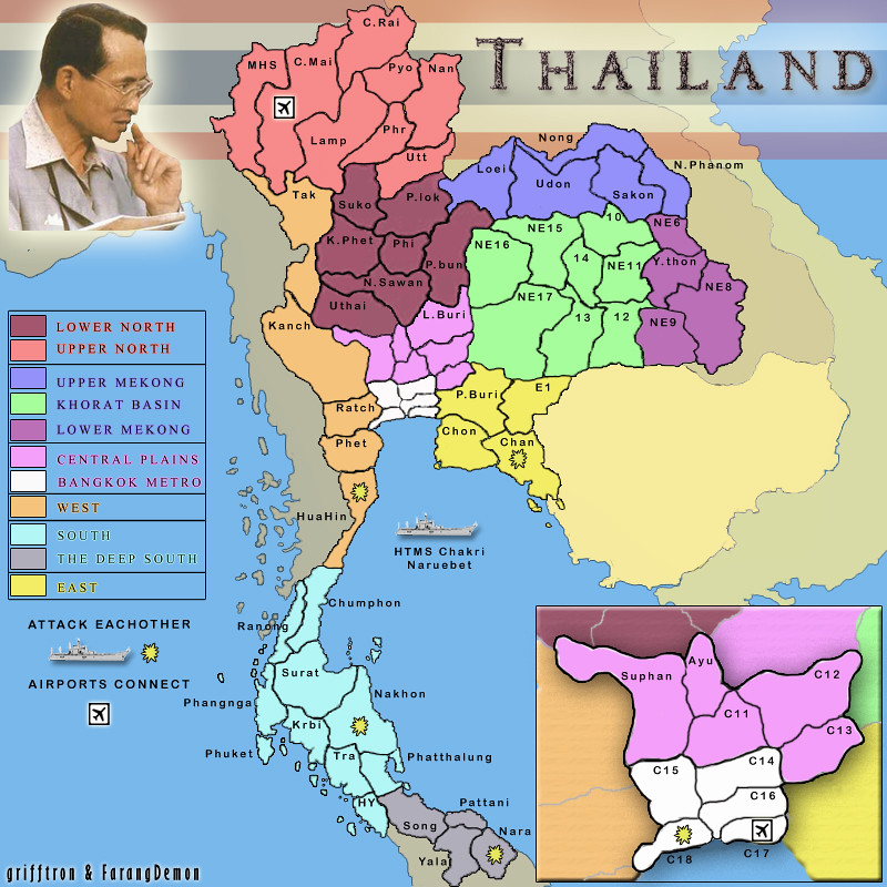
Merged a couple more that were suggested by RedBaron, rest should be fine now on both large and small versions of the map. I started putting in some names as well.. obviously not all yet. Just wanted to see how it looked.
-griff
-griff
-
grifftron
- SoC Training Adviser
- Posts: 3280
- Joined: Thu Jul 09, 2009 6:11 am
Re: Thailand
![]() by porkenbeans on Thu Sep 09, 2010 2:11 pm
by porkenbeans on Thu Sep 09, 2010 2:11 pm
Griff, can you re-post the image with "big image" tags ?
That way the avatar will not cover it up, in the upper right.
About the labels,
They look great, but I would really like to see the full names, (instead of abbreviations). I realize that some of the names are rather long, but unless there is no available space, I believe that this map is screaming for the full name. You have a whole lot of space available outside of the Thailand perimeter, so all of those territs that are on that perimeter, have plenty of space for their full name. I would only use abbreviations, on the interior territs, that are too small for the full names.
Also, can you post a large and/or small version. The extra large is not helping, to properly visualize the map. we need to see what the text looks like in its actual size.
Keep on keepin on, it's looking really good.
Last edited by porkenbeans on Thu Sep 09, 2010 2:31 pm, edited 3 times in total.
-
porkenbeans
- Posts: 2546
- Joined: Mon Sep 10, 2007 4:06 pm
Re: Thailand
![]() by The Bison King on Thu Sep 09, 2010 2:19 pm
by The Bison King on Thu Sep 09, 2010 2:19 pm
Now we're talking! that's a huge visual improvment!
-
The Bison King
- Posts: 1957
- Joined: Thu Aug 27, 2009 5:06 pm
- Location: the Mid-Westeros
Re: Thailand
![]() by grifftron on Thu Sep 09, 2010 8:22 pm
by grifftron on Thu Sep 09, 2010 8:22 pm
porkenbeans wrote:Griff, can you re-post the image with "big image" tags ?
That way the avatar will not cover it up, in the upper right.
sure.
About the labels,
They look great, but I would really like to see the full names, (instead of abbreviations). I realize that some of the names are rather long, but unless there is no available space, I believe that this map is screaming for the full name. You have a whole lot of space available outside of the Thailand perimeter, so all of those territs that are on that perimeter, have plenty of space for their full name. I would only use abbreviations, on the interior territs, that are too small for the full names.
yep ok, Farang is correcting some of the names right now and has sent me a list already so i will add that to the next update.
Also, can you post a large and/or small version. The extra large is not helping, to properly visualize the map. we need to see what the text looks like in its actual size.
I work with flickr... the offer diff sizes of each picture you d/l... can i just use the 640x640 i will post it below.. otherwise i can just resize it in photoshop.. use this for now i guess..
Keep on keepin on, it's looking really good.
small 640x640
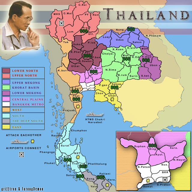
large 800x800
- Click image to enlarge.

-griff
-
grifftron
- SoC Training Adviser
- Posts: 3280
- Joined: Thu Jul 09, 2009 6:11 am
Who is online
Users browsing this forum: No registered users
|
|||||||
| Conquer Club is not associated with RISK online in any way. Copyright © 2006-2024 by Big Wham LLC | |||||||