Page 21 of 23
Going well.

Posted:
Thu Jul 26, 2007 9:05 pmby Solus
I think it's beyond critique... maybe. It looks good and I'm ready to play on it.
Posted:
Fri Jul 27, 2007 1:24 pmby AndyDufresne
In reference to Rev. Kyle's post, I think he means the raised texture of where the land 'use to be'. I think it looks alright though
--Andy
Posted:
Fri Jul 27, 2007 1:28 pmby Coleman
pepperonibread wrote:reverend_kyle wrote:I don't know if this has been mentioned and maybe its too late, but this map needs cleaned up majorly near alaska and greenland, and I'm not a fan of the texture.
What does "cleaned up" mean? I don't see anything wrong with these areas.
I think he didn't get the fact that you were doing a water elevation effect with that section, where the water isn't near as high over the land there as it is in the ocean so you used a different texture.
I was really hoping Andy's last post was the quench.

Posted:
Fri Jul 27, 2007 2:38 pmby pepperonibread
Coleman wrote:I was really hoping Andy's last post was the quench.
Yep, me too.

Posted:
Fri Jul 27, 2007 8:44 pmby Solus
pepperonibread wrote:Coleman wrote:I was really hoping Andy's last post was the quench.
Yep, me too.
It's basically perfected...

Posted:
Sun Jul 29, 2007 8:40 pmby HighCommander540
reverend_kyle wrote:I don't know if this has been mentioned and maybe its too late, but this map needs cleaned up majorly near alaska and greenland, and I 'm not a fan of the texture.
^I am pretty sure this guy is crazy^
Re: Going well.
Posted:
Mon Jul 30, 2007 11:48 amby unriggable
Solus wrote:I think it's beyond critique... maybe. It looks good and I'm ready to play on it.
QFT
Posted:
Mon Jul 30, 2007 7:06 pmby tim02
looks amazing now just hurry up so we can play it
Posted:
Mon Jul 30, 2007 7:10 pmby AndyDufresne
Hm, it's looking nice, and close.
Something I'd see if you can clarify are the SA borders, especially the Argentina and Brazil one...it's small and the border line looks kind of gray and faded. There are a number of other faded spots, so perhaps look around at the other borders as well.
And on the large map, maybe move the Quebec coordinate slightly away from the border near New England. A tad bit more space.
A few of the sea connections don't look like the touch the land, near Brazil is one. There might be a few others. Quick looks there.
But it's looking good.

--Andy
Posted:
Mon Jul 30, 2007 7:11 pmby pepperonibread
tim02 wrote:looks amazing now just hurry up so we can play it
Yeah, I think so too. Just waiting for the quench.
Posted:
Mon Jul 30, 2007 11:37 pmby pepperonibread
AndyDufresne wrote:Hm, it's looking nice, and close.
Something I'd see if you can clarify are the SA borders, especially the Argentina and Brazil one...it's small and the border line looks kind of gray and faded. There are a number of other faded spots, so perhaps look around at the other borders as well.
And on the large map, maybe move the Quebec coordinate slightly away from the border near New England. A tad bit more space.
A few of the sea connections don't look like the touch the land, near Brazil is one. There might be a few others. Quick looks there.
But it's looking good.
--Andy
Regarding the sea routes, the bevel of the black continent outlines is just going over them, so they seem to end slightly early. The other stuff will be fixed. Also, I assume
this thread means I should update my XML so "territory" replaces "country"?
Posted:
Tue Jul 31, 2007 12:15 amby KEYOGI
If that's the case with the sea routes, couldn't you just adjust your layer order to fix the problem?
And yes, the XML will need to be updated with <territory> tags replacing the <country> ones.
Posted:
Tue Jul 31, 2007 9:13 amby pepperonibread
KEYOGI wrote:If that's the case with the sea routes, couldn't you just adjust your layer order to fix the problem?
And yes, the XML will need to be updated with <territory> tags replacing the <country> ones.
I'll try, but there is also a bevel on the sea routes, so that may overlap the continents. However, I'm going to see what happens if I flatten the bevel so it's no longer a layer effect, then maybe I can erase the part over the sea route.
Posted:
Tue Jul 31, 2007 4:58 pmby KEYOGI
Perhaps a little bit of brush work then. I see no reason why it can't be fixed.
MAP
Posted:
Wed Aug 01, 2007 6:52 pmby Suntzu
I SAID 5 ARMIES .6 points of attack,,,,,,,,,i am sorry it should be 4 armies. SUNTZU
Posted:
Thu Aug 02, 2007 6:45 pmby pepperonibread
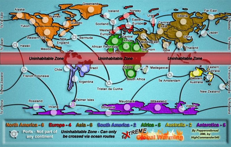
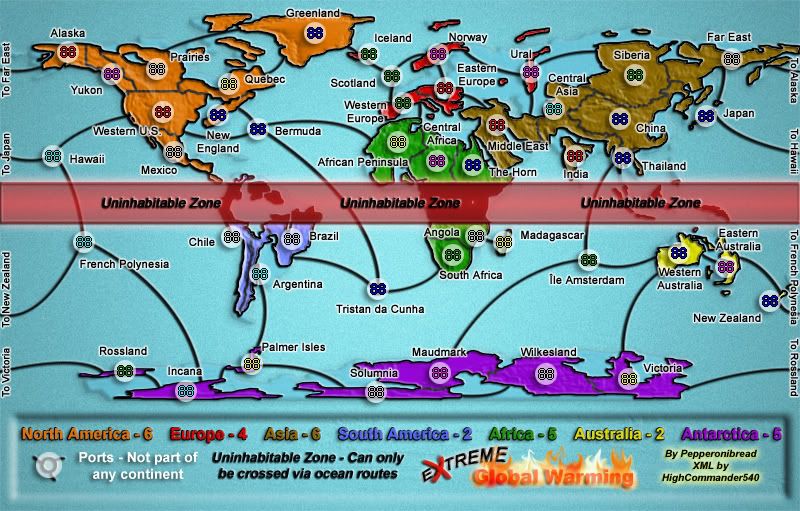
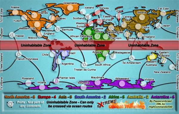
New Update:
Large:
Large w/ XML:
Small:
Small w/ XML:
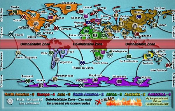
Changes:
-Moved Quebec and Incana army circles (large map)
-Made ocean routes connect to black continent borders
-Cleared up country borders in S. America
-Fixed XML to say territory instead of country
-Adjusted all XML coordinates accordingly
Posted:
Fri Aug 03, 2007 1:05 pmby tenio
good job, looks great!
Posted:
Fri Aug 03, 2007 2:45 pmby tim02
how long till you think it will be quenched
Posted:
Fri Aug 03, 2007 6:49 pmby pepperonibread
tim02 wrote:how long till you think it will be quenched
Whenever the mods are satisfied.
Posted:
Fri Aug 03, 2007 7:16 pmby tim02
then if the modes are smart it should be soon
Posted:
Mon Aug 06, 2007 10:08 amby wrightfan123
good job, Pepperoni. nice work getting the SA borders fixed.
Posted:
Mon Aug 06, 2007 11:31 amby RobinJ
pepperonibread wrote:tim02 wrote:how long till you think it will be quenched
Whenever the mods are satisfied.
So long as nobody complains for the next few days - great map!
Posted:
Mon Aug 06, 2007 11:38 amby Coleman
If anyone has a real complaint I'll break their kneecaps like my left one is broken right now. With a hammer... a claw hammer.
Posted:
Mon Aug 06, 2007 11:42 amby hulmey
Posted:
Mon Aug 06, 2007 11:43 amby Coleman
hulmey wrote::oops:
I'm watching you...

