Page 1 of 14
High Seas [Quenched]

Posted:
Thu Jan 10, 2008 1:35 amby oaktown
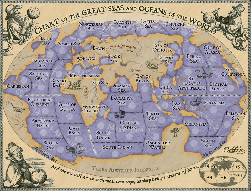
Alright, this map idea has been tried about a dozen times, all with no success. It is the earth, from a fish's perspective. For my attempt I am borrowing much that was learned in Viscount Gort's abandoned attempt, including some territory names and the basic projection of the globe. I invite you to read the discussions on his old map thread:
viewtopic.php?t=12132&start=0- Click image to enlarge.
Basics:
42 total territories, no neutral starts.
Large map: 800pix x 610 pix
Small map: 630x480 pix
No gimmicks or tricky rules - we're going classic gameplay on this one.
Graphics: I was going to go 19th century moby dick, but I seem to have stepped back in time a bit. Now we've gone fully 16th century, with California as an island and Australia as a big lump of terra incognita. The characters in the corners are pulled from an early 16th century engraving by Albrecht Durer.
Note: as I couldn't very well stamp my own map, I deputized EdBeard to oversee the game mechanics stamp on this one. Thanks, Ed.
Posted:
Thu Jan 10, 2008 9:04 amby Sven Hassel
do you really want to do a 24 territorie map, water represents 2/3 of the world, you could do a big map on this one because of the multitude of seas?
Posted:
Thu Jan 10, 2008 9:11 amby Lone.prophet
this would make a very nice map though maybe make some more territories, bays panama canal and so on
Posted:
Thu Jan 10, 2008 9:15 amby oaktown
Sven Hassel wrote:do you really want to do a 24 territory map, water represents 2/3 of the world, you could do a big map on this one because of the multitude of seas?
my initial idea (based on Viscount Gort's attempt at this) was a standard 42 terit map, with the Atlantic and Pacific split into North and South bonuses, but my sense is that there is demand for another small map.... I could be talked into going either way.
Posted:
Thu Jan 10, 2008 9:17 amby Lone.prophet
yeah though 24 is a bit to small i think
Posted:
Thu Jan 10, 2008 9:31 amby rebelman
there is a demand for small maps but this merits a bigger map i think
Posted:
Thu Jan 10, 2008 10:51 amby Balsiefen
I take it you're planning to get different names than what you've got?
Posted:
Thu Jan 10, 2008 10:58 amby Tense
Lake Victoria in South America and Lake Baykal in Russia, you have forgotten!
Perhaps they are too small? - imo no, just make them large enough.
The baltic sea, etc etc. There are lots of names of the part of the atlantic ocean than just the Atl 3. I guess you know that and have written so, somewhere.
Posted:
Thu Jan 10, 2008 11:01 amby Lone.prophet
yoou can give the water between england holland and norway "north sea'
Posted:
Thu Jan 10, 2008 12:18 pmby rebelman
Tense wrote:Lake Victoria in South America and Lake Baykal in Russia, you have forgotten!
Perhaps they are too small? - imo no, just make them large enough.
The baltic sea, etc etc. There are lots of names of the part of the atlantic ocean than just the Atl 3. I guess you know that and have written so, somewhere.
assuming seas contain salt water these are the largest:
Order Name Area in sq mi (sq km)
1. Pacific Ocean 60,060,893 (155,557,000)
2. Atlantic Ocean 29,637,974 (76,762,000)
3. Indian Ocean 26,469,620 (68,556,000)
4. Southern Ocean 7,848,299 (20,327,000)
5. Arctic Ocean 5,427,052 (14,056,000)
6. South China Sea 1,148,500 (2,974,600)
7. Caribbean Sea 971,394 (2,515,900)
8. Mediterranean Sea 969,116 (2,510,000)
9. Bering Sea 872,977 (2,261,000)
10. Gulf of Mexico 582,088 (1,507,600)
11. Sea of Okhotsk 537,493 (1,392,100)
12. Sea of Japan/East Sea 391,083 (1,012,900)
13. Hudson Bay 281,893 (730,100)
14. East China Sea 256,372 (664,000)
15. Andaman Sea 218,109 (564,900)
16. Black Sea 196,101 (507,900)
17. Red Sea 174,904 (453,000)
18. Baltic Sea 61,004 (158,000)
19. Caspian Sea 58,735 (152,123)
these are the largest freshwater (lakes) (the caspian sea athough a lake contains salt water hence its inclusion above)
Order Name and location Area in sq mi (sq km)
1. Lake Superior, US/Canada 31,820 (82,413)
2. Lake Victoria, Uganda/Tanzania/Kenya 26,828 (69,484)
3. Lake Huron, US/Canada 23,010 (59,596)
4. Lake Michigan, US 22,400 (58,016)
5. Lake Tanganyika, Tanzania 12,355 (31,999)
6. Lake Baikal, Russia 12,162 (31,499)
7. Great Bear Lake, Canada 12,000 (31,080)
8. Great Slave Lake, Canada 11,170 (28,930)
9. Lake Nyasa, Tanzania/Mozambique/Malawi 10,900 (28,231)
10. Lake Erie, Canada 9,940 (25,744)
11. Winnipeg Lake, Canada 9,094 (23,553)
12. Lake Ontario, US/Canada 7,540 (19,529)
Posted:
Thu Jan 10, 2008 12:25 pmby Lone.prophet
north sea 222,000 square miles
Posted:
Thu Jan 10, 2008 3:15 pmby oaktown
the names are temporary - I'd like to settle on map size before I waste time naming things.
In addition to adding territories to the oceans, I was thinking about throwing in some port cities that start neutral. I'd have to settle on a time period (pre-Panama canal, post-Suez?) for the map and figure out what the key ports were in that day.
My idea is to make the ports an alternative source of bonus armies (or in this case navies). Maybe say that you get +1 auto-deployed navy on each port, or +1 navy for every two ports owned. This would off-set the difficulty faced by players who start in the larger regions - Atlantic and Pacific - since the majority of the ports would border the big oceans.
I'm thinking maybe 32 starting territories and ten ports? Or 36 and 6? Something along those lines to bring the total map size to classic level.
Posted:
Thu Jan 10, 2008 5:34 pmby benny profane
this seems like it can be a great map.
i like the idea of the ports.
but, it feels like this might be better as a large map.
also, as a suggestion, maybe you could consider incorporating actual ocean currents into the gameplay?


Posted:
Thu Jan 10, 2008 6:51 pmby mibi
the asia-centric aspect doesn't jive with my xenophobic world view.
Posted:
Thu Jan 10, 2008 7:10 pmby yeti_c
I'd consider putting the split down Middle-East and Indian Ocean... instead America-Asia...
C.
Posted:
Thu Jan 10, 2008 8:12 pmby oaktown
yeti_c wrote:I'd consider putting the split down Middle-East and Indian Ocean... instead America-Asia...
C.
The debate over where to split the map was waged in Viscount Gort's previous thread on this topic. I invite you all to read the lengthy discussions on where to split the map.
http://www.conquerclub.com/forum/viewtopic.php?t=12132
In my version I have gone with the split that Gort ended up settling on, so by choosing this configuration I was hoping to save us the time and energy of rehashing an old discussion. Plus, this is the split that I initially suggested in that thread and continue to feel is the best for a number of reasons.
Sea currents are interesting, but wind currents would more accurately represent how ships can move about on oceans... trade winds that take you east in one direction and west in the other, one way attacks with the wind, etc. However, I'd like to keep this simple - plenty of folks are making complex maps, and I'd like to keep the funky game mechanics to a minimum.
Posted:
Thu Jan 10, 2008 8:13 pmby AndyDufresne
It'll be interesting to see how this idea goes...I've had high hopes for this one ever since it was started years ago! I'd like the map to have 30+ territories, but perhaps not the standard 42.
--Andy
Posted:
Fri Jan 11, 2008 2:06 amby oaktown
AndyDufresne wrote:It'll be interesting to see how this idea goes...I've had high hopes for this one ever since it was started years ago! I'd like the map to have 30+ territories, but perhaps not the standard 42.
--Andy
I'm thinking 30-something starting terits, with some neutral starts to bring it into the 40s. I'll play with it this weekend.
Posted:
Fri Jan 11, 2008 4:11 amby yeti_c
oaktown wrote:yeti_c wrote:I'd consider putting the split down Middle-East and Indian Ocean... instead America-Asia...
C.
The debate over where to split the map was waged in Viscount Gort's previous thread on this topic. I invite you all to read the lengthy discussions on where to split the map.
http://www.conquerclub.com/forum/viewtopic.php?t=12132In my version I have gone with the split that Gort ended up settling on, so by choosing this configuration I was hoping to save us the time and energy of rehashing an old discussion. Plus, this is the split that I initially suggested in that thread and continue to feel is the best for a number of reasons.
Sea currents are interesting, but wind currents would more accurately represent how ships can move about on oceans... trade winds that take you east in one direction and west in the other, one way attacks with the wind, etc. However, I'd like to keep this simple - plenty of folks are making complex maps, and I'd like to keep the funky game mechanics to a minimum.
Fair enough... Just thought I'd mention it... to make sure you were aware of that idea.
C.
Posted:
Fri Jan 11, 2008 8:59 amby mibi
can pac7 attack atl5?
Posted:
Fri Jan 11, 2008 9:04 amby rebelman
since 2000 the southern Ocean is recognised as an Ocean in its own right i think it should also be included along with the other oceans.
Posted:
Fri Jan 11, 2008 12:36 pmby Coleman
Agree with rebelman.
My weakness is gameplay / map layout so I can't be very helpful there. Especially since I find the orientation a bit odd. From a visual standpoint I'd be happier with a smaller territory name text if it meant you could get the full names (Arctic 1 instead of Arc 1 for example).
Posted:
Sat Jan 12, 2008 8:07 pmby oaktown
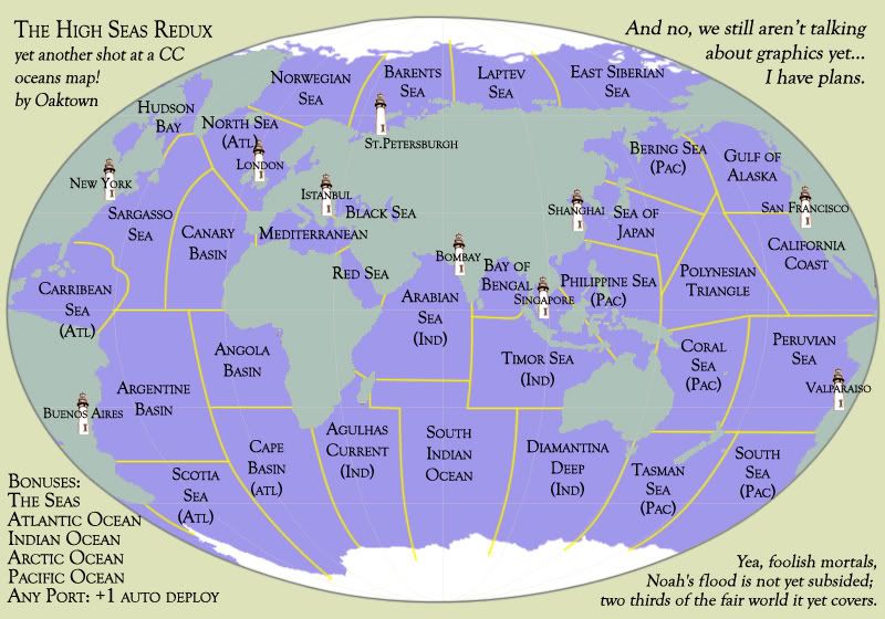
High Seas Redux, reduxed.
Play: The map now stands at 32 starting territories, plus 10 neutral-starting Seaports. The 32 starting terits will each be a part of bonus region, and the ports will not but will earn you a +1 auto-deploy per turn.
The bonus regions look like this, with my initial thought for bonuses:
edit: removed early bonus info to avoid confusion... see first post.
Graphics: still in the works. I'm leaning toward a Victorian, 19th century, Moby Dick feel.
Posted:
Sat Jan 12, 2008 8:56 pmby newline
i don't think this has been brought up yet, but Alaska and Russia don't touch. the Bearing Sea and the East Siberian Sea count connect
Posted:
Sat Jan 12, 2008 9:11 pmby pepperonibread
klupar wrote:i don't think this has been brought up yet, but Alaska and Russia don't touch. the Bearing Sea and the East Siberian Sea count connect
I think it's a slight tweak to help the gameplay of the map.