thanks fellas. I'm adding to my to-do list...
• Now that I look at I think the animals need a dark brown layer mask, or sepia them - they're too black next to the other land elements.
• I'd like to get the Great Seas off of the borders a bit more... perhaps I should make the text a bit smaller.
• Make the Baffin Bay border convex, not concave.
• I'm still not thinking that the mini map looks right. Grrr...
High Seas [Quenched]
Moderator: Cartographers
Re: High Seas, update pg.10 [I, GP]
![]() by yeti_c on Fri Apr 11, 2008 12:55 am
by yeti_c on Fri Apr 11, 2008 12:55 am
Latest changes sort any problem I had with blandness - nice job.
C.
C.

Highest score : 2297
-

 yeti_c
- Posts: 9624
- Joined: Thu Jan 04, 2007 9:02 am


Re: High Seas, update pg.10 [I, GP]
![]() by gimil on Fri Apr 11, 2008 6:59 am
by gimil on Fri Apr 11, 2008 6:59 am
I have no real concerns except what you have already mentioned. Lets give te community time before I think about stamping it 
What do you know about map making, bitch?
Top Score:2403
natty_dread wrote:I was wrong
Top Score:2403
-

gimil
- Posts: 8599
- Joined: Sat Mar 03, 2007 12:42 pm
- Location: United Kingdom (Scotland)


Re: High Seas, update pg.10 [I, GP]
![]() by RjBeals on Fri Apr 11, 2008 7:24 am
by RjBeals on Fri Apr 11, 2008 7:24 am
Nice as is. Dont add anything else or it will tip over the edge of being too cluttered and confusing. By all means adjust contrast or tones or whatever you think needs tweaking. Nicely done Oaktown. A very unique map that I think will be a big hit with the general players.

-

RjBeals
- Posts: 2506
- Joined: Mon Nov 20, 2006 5:17 pm
- Location: South Carolina, USA


Re: High Seas, update pg.10 [I, GP]
![]() by oaktown on Fri Apr 11, 2008 9:24 pm
by oaktown on Fri Apr 11, 2008 9:24 pm
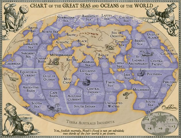
Large image:
Small image:

Made changes as noted above... nothing spectacular, just some little things that bugged me. I realize now that I'm slowly pushing the little map to have a similar contrast to the guys in the corners... otherwise the balance is bad. I'll keep fussing with it.
Just realized i forgot to resize the army circles on this small post... you get the idea though.
- Click image to enlarge.
Small image:
Made changes as noted above... nothing spectacular, just some little things that bugged me. I realize now that I'm slowly pushing the little map to have a similar contrast to the guys in the corners... otherwise the balance is bad. I'll keep fussing with it.
Just realized i forgot to resize the army circles on this small post... you get the idea though.

-
oaktown
- Posts: 4451
- Joined: Sun Dec 03, 2006 9:24 pm
- Location: majorcommand


Re: High Seas, update pg.11 [I, GP]
![]() by hulmey on Sat Apr 12, 2008 6:20 am
by hulmey on Sat Apr 12, 2008 6:20 am
i like this map , but from a gameplay point of view, im quite certain that if u get the right placement, then its game over, before its started!
[img]http://img801.imageshack.us/img801/9761/41922610151374166770386.jpg[/mg]
-

hulmey
- Posts: 3742
- Joined: Fri Nov 03, 2006 7:33 am
- Location: Las Vegas


Re: High Seas, update pg.11 [I, GP]
![]() by gimil on Sat Apr 12, 2008 8:06 am
by gimil on Sat Apr 12, 2008 8:06 am
hulmey wrote:i like this map , but from a gameplay point of view, im quite certain that if u get the right placement, then its game over, before its started!
Why dont you tell oaktown how that is? then so he can give attention to the issues . . .
What do you know about map making, bitch?
Top Score:2403
natty_dread wrote:I was wrong
Top Score:2403
-
gimil
- Posts: 8599
- Joined: Sat Mar 03, 2007 12:42 pm
- Location: United Kingdom (Scotland)
Re: High Seas, update pg.11 [I, GP]
![]() by hulmey on Sat Apr 12, 2008 8:44 am
by hulmey on Sat Apr 12, 2008 8:44 am
in most places to own a continent you only need to hold one or 2 countries in the right position! unfortunately there is nothing he can really do about it, but start over again! Its a pity coz the map is beautiful and very different (theme wise) to the ones we have on offer right now!
[img]http://img801.imageshack.us/img801/9761/41922610151374166770386.jpg[/mg]
-
hulmey
- Posts: 3742
- Joined: Fri Nov 03, 2006 7:33 am
- Location: Las Vegas
Re: High Seas, update pg.11 [I, GP]
![]() by oaktown on Sat Apr 12, 2008 10:30 am
by oaktown on Sat Apr 12, 2008 10:30 am
hulmey wrote:in most places to own a continent you only need to hold one or 2 countries in the right position! unfortunately there is nothing he can really do about it, but start over again! Its a pity coz the map is beautiful and very different (theme wise) to the ones we have on offer right now!
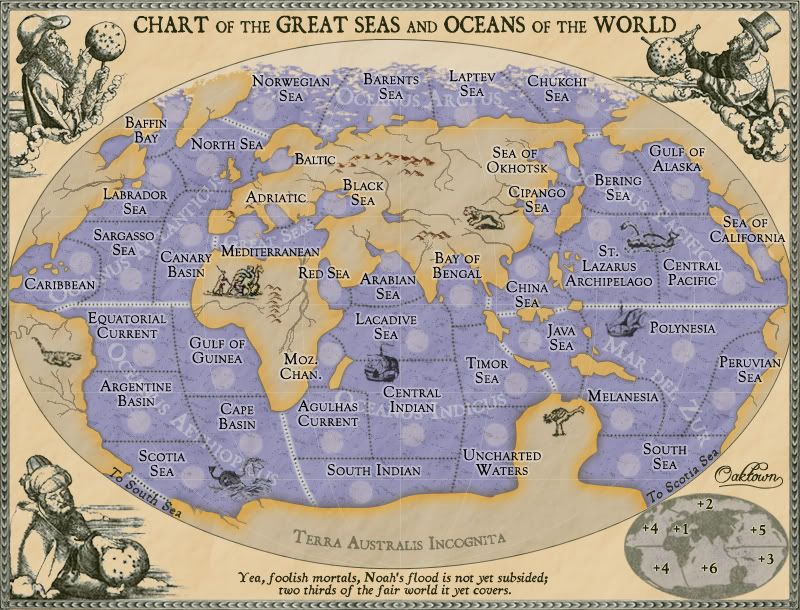
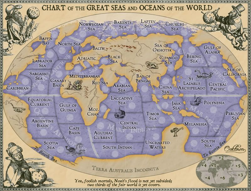
Funny, I'd thought it was the other way around! But if you are seeing choke points I haven't caught I'd like to hear more, hulmey, as I'm not opposed to making changes. Here are the the bonus region break-downs:
Arctic: 4 terits, 2 borders, +2
Atlanticus: 7 terits, 4 borders, +4
Seas: 3 terits, 1 border, +1
Ethiopicus: 5 terits, 4 borders, +4
Indicus: 10 terits, 4 borders, +6
Zur: 5 terits, 3 borders, +3
Pacificus: 8 terits, 4 borders, +5
I was trying to apply the same basic rules used the Classic map in this one in terms of overall size and bonus structure. I have regions with 1, 2, and 3 borders to defend; that's the same configuration as Classic, with my three smallest regions (Seas, Arctic, Zur) being similar in size, borders, and bonus to Australia (4/1/+2), S. Am. (4/2/+2), and Africa (6/3/+3).
Classic then has North America which is a three border region as well, which could be compared to Pacificus in this map because if you expand to take Polynesia from pacificus you only have three places to hold - a 9 terit, 3 border +5 which equals N. Am.
Atlanticus is similar to Europe - 7 terits, 4 borders, +5... 1 lone northern border, three contiguous southern borders.
Where I differ from Classic the most is that this map doesn't have a behemoth region like Asia. I've shaved a territory here and there to come up with 7 regions (7 seas?) instead of 6, because in my humble opinion Asia is usually a wasteland in most games anyway. Indicus may end up facing a similar fate, but if you find yourself starting there you won't be in quite as much trouble as a bad Asia start.
If there's a region I am not pleased with on this map, it is the Arctic Ocean. Its linear nature makes it easy to march through one step at a time, which will make it a clear target in games, but that same feature also makes it easier to defend from attack I guess. Plus, that's just the way the world is, so I can live with it.
-
oaktown
- Posts: 4451
- Joined: Sun Dec 03, 2006 9:24 pm
- Location: majorcommand
Re: High Seas, update pg.11 [I, GP]
![]() by iancanton on Sun Apr 13, 2008 7:18 am
by iancanton on Sun Apr 13, 2008 7:18 am
oaktown
this is a marvellous creation.
the arctic still has the "extreme global warming" look, primarily because europe and africa need to be moved northward by a centimetre and some of asian russia ought to be expanded northward. the equator was one line that mariners of the time were able to measure accurately, so they knew where it intersected africa. this is a 1569 example from the great man himself, gerardus mercator.
http://en.wikipedia.org/wiki/Image:Mercator_1569.png
acrtic ocean is oceanus arcticus, not oceanus arctus: look at the text on the flagon on the pusser's rum webpage below (not a definitive source, but it sounds right).
http://www.pussers.com/rum/products/flagon/popup
at the bottom of that webpage is a list of the seven seas as pussers saw it: indian ocean is mare indicum (sea of india – the john speed 1651 world map to which i've linked below calls it indian sea) rather than oceanus indicus, which is the direct translation of the modern name. my latin grammar isn't up to explaining the -um ending.
http://www.oldmap.co.uk/TheWorld.html
in latin inscriptions, it was a common convention to use the letter v instead of u, since the romans wrote u as v. this is certainly the case on many public buildings and pre-decimal coinage, for example post-ww2 period, in the uk. clicking on picture number 2 shows a close-up of a coin where george is rendered as georgivs.
http://www.royalmint.com/PackedSets/AGLSD.aspx
perhaps u can apply this to the continent names (unless u think there is confusion caused by there being a real v or two in the territory names).
laccadive has two Cs.
have u considered a thin outer glow of deeper blue where the sea meets the land (much as u've done with the land where it meets the sea) and also at the border of each continent?
the "land monsters" are fun.
ian.
this is a marvellous creation.
jasnostj wrote:you can have more ice in the Arctic, and thus lose the extreme global warming look.
the arctic still has the "extreme global warming" look, primarily because europe and africa need to be moved northward by a centimetre and some of asian russia ought to be expanded northward. the equator was one line that mariners of the time were able to measure accurately, so they knew where it intersected africa. this is a 1569 example from the great man himself, gerardus mercator.
http://en.wikipedia.org/wiki/Image:Mercator_1569.png
acrtic ocean is oceanus arcticus, not oceanus arctus: look at the text on the flagon on the pusser's rum webpage below (not a definitive source, but it sounds right).
http://www.pussers.com/rum/products/flagon/popup
at the bottom of that webpage is a list of the seven seas as pussers saw it: indian ocean is mare indicum (sea of india – the john speed 1651 world map to which i've linked below calls it indian sea) rather than oceanus indicus, which is the direct translation of the modern name. my latin grammar isn't up to explaining the -um ending.
http://www.oldmap.co.uk/TheWorld.html
in latin inscriptions, it was a common convention to use the letter v instead of u, since the romans wrote u as v. this is certainly the case on many public buildings and pre-decimal coinage, for example post-ww2 period, in the uk. clicking on picture number 2 shows a close-up of a coin where george is rendered as georgivs.
http://www.royalmint.com/PackedSets/AGLSD.aspx
perhaps u can apply this to the continent names (unless u think there is confusion caused by there being a real v or two in the territory names).
laccadive has two Cs.
have u considered a thin outer glow of deeper blue where the sea meets the land (much as u've done with the land where it meets the sea) and also at the border of each continent?
the "land monsters" are fun.
ian.
-

iancanton
- Foundry Foreman

- Posts: 2424
- Joined: Fri Jun 01, 2007 5:40 am
- Location: europe


Re: High Seas, update pg.11 [I, GP]
![]() by oaktown on Mon Apr 14, 2008 12:34 am
by oaktown on Mon Apr 14, 2008 12:34 am
- Click image to enlarge.

Thanks iancanton... I've implemented most of your suggestions, as follows:
iancanton wrote:the arctic still has the "extreme global warming" look, primarily because europe and africa need to be moved northward by a centimetre and some of asian russia ought to be expanded northward.
Alright, I've moved the entire eastern hemisphere up a bit, and screwed up most of my territory borders in the process - if anybody sees something that's off, please let me know! I acknowledge that africa is still too low, but I've taken the liberty of showing it incorrectly because otherwise the northern hemisphere territories are going to be an absolutely mess. As for ancient mariners getting the geography correct, you're absolutely right. But the mapmakers of the day generally weren't so knowledgeable, and they often took liberties or just plain made things up, as I have.
iancanton wrote:acrtic ocean is oceanus arcticus, not oceanus arctu... indian ocean is mare indicum
Done and done. Thanks.
iancanton wrote:in latin inscriptions, it was a common convention to use the letter v instead of u, since the romans wrote u as v. this is certainly the case on many public buildings and pre-decimal coinage, for example post-ww2 period, in the uk. clicking on picture number 2 shows a close-up of a coin where george is rendered as georgivs... perhaps u can apply this to the continent names (unless u think there is confusion caused by there being a real v or two in the territory names).
I've put the "V"s in the region names, but as the territory titles aren't subscribing to the latin they're best as is.
iancanton wrote:laccadive has two Cs.
done.
iancanton wrote:have u considered a thin outer glow of deeper blue where the sea meets the land (much as u've done with the land where it meets the sea) and also at the border of each continent?
The land had both an outer and an inner glow - I've changed the outer glow to a deeper blue, and put a similar (though lighter) glow around the territory titles. Region borders I've left as is.
Thanks again for all the time you put into this one ian!
-
oaktown
- Posts: 4451
- Joined: Sun Dec 03, 2006 9:24 pm
- Location: majorcommand
Re: High Seas, update pg.11 [I, GP]
![]() by asl80 on Mon Apr 14, 2008 6:07 am
by asl80 on Mon Apr 14, 2008 6:07 am
hehe- love the emu in terra australis oaktown (great map too ... sorry, haven't much time for comments on maps at the moment), but in case of confusion with the african ostritch, how about an image of one of the more iconic marsupials ... i pose the challange to find an image of a wombat or a wallaby in a similar style as the other animals oaktown.
hehe ... good luck
(p.s. this would seem like a little consulation to those of us down on this continent who's landmass has been morphed and conjoined with the ice continent for the mere purposes of historical accuracy, or something equally unimportant, hehehe)
hehe ... good luck
(p.s. this would seem like a little consulation to those of us down on this continent who's landmass has been morphed and conjoined with the ice continent for the mere purposes of historical accuracy, or something equally unimportant, hehehe)
-
asl80
- Posts: 208
- Joined: Wed Jun 27, 2007 10:07 am

Re: High Seas, update pg.11 [I, GP]
![]() by oaktown on Mon Apr 14, 2008 8:28 am
by oaktown on Mon Apr 14, 2008 8:28 am
asl80 wrote:hehe- love the emu in terra australis oaktown (great map too ... sorry, haven't much time for comments on maps at the moment), but in case of confusion with the african ostritch, how about an image of one of the more iconic marsupials ... i pose the challange to find an image of a wombat or a wallaby in a similar style as the other animals oaktown.
I could just draw a more appropriate animal, but that would miss the point. The idea I have in my head for that part of the map is that the mapmaker doesn't really know what the hell is going on with that part of the world - reports of some big land mass south of China; size, features, flora and fauna undetermined. So the animal that gets placed there is the weirdest one that the mapmaker has in his arsenal, a long-legged, flightless bird with a funny tail. I would sooner put a fire-breathing dragon there than an animal that actually exists and is appropriate to the region!
-
oaktown
- Posts: 4451
- Joined: Sun Dec 03, 2006 9:24 pm
- Location: majorcommand
Re: High Seas, update pg.11 [I, GP]
![]() by ZeakCytho on Mon Apr 14, 2008 3:08 pm
by ZeakCytho on Mon Apr 14, 2008 3:08 pm
I love the animal images on the land, but I think they're a bit too bright/distracting. Could you turn the opacity down just a bit on them?
I can't wait to play this map, by the way.
I can't wait to play this map, by the way.
Last edited by ZeakCytho on Mon Apr 14, 2008 9:10 pm, edited 1 time in total.
-

ZeakCytho
- Posts: 1251
- Joined: Wed Sep 12, 2007 4:36 pm


Re: High Seas, update pg.11 [I, GP]
![]() by Sir. Ricco on Mon Apr 14, 2008 7:12 pm
by Sir. Ricco on Mon Apr 14, 2008 7:12 pm
I really like what you have done. The graphics look great. The bonuses are fair. This needs to be in the Final Forge. 


-

Sir. Ricco
- Posts: 4555
- Joined: Tue Oct 02, 2007 2:33 pm
- Location: Making kingdoms burn and bloodshed start.


Re: High Seas, update pg.11 [I, GP]
![]() by oaktown on Tue Apr 15, 2008 10:23 pm
by oaktown on Tue Apr 15, 2008 10:23 pm
It has been a quiet night here in the Foundry, so I wrote some code. No coordinates yet as things aren't quite finalized, but it came through the XML checker error free.
- Code: Select all
<?xml version="1.0"?>
<map>
   <title>High Seas</title>
   <smallwidth>630</smallwidth>
   <smallheight>480</smallheight>
   <largewidth>800</largewidth>
   <largeheight>610</largeheight>
   <filetype>jpg</filetype>

   <continent>
      <name>Mar del Zur</name>
      <bonus>3</bonus>
      <components>
         <territory>Polynesia</territory>
         <territory>Preuvian Sea Territory</territory>
         <territory>Melanesia</territory>
         <territory>java Sea</territory>
         <territory>South Sea</territory>
      </components>
   </continent>

   <continent>
      <name>Oceanus Pacificus</name>
      <bonus>5</bonus>
      <components>
         <territory>Sea of California</territory>
         <territory>Gulf of Alaska</territory>
         <territory>Bering Sea</territory>
         <territory>Cipango Sea</territory>
         <territory>China Sea</territory>
         <territory>St. Lazarus Archipelago</territory>
         <territory>Sea of Okhotsk</territory>
         <territory>Central Pacific</territory>
         </components>
   </continent>

   <continent>
      <name>Oceanus Arcticus</name>
      <bonus>2</bonus>
      <components>
         <territory>Chukchi Sea</territory>
         <territory>Laptev Sea</territory>
         <territory>Barents Sea</territory>
         <territory>Norwegian Sea</territory>
      </components>
   </continent>

   <continent>
      <name>Mare Indicum</name>
      <bonus>6</bonus>
      <components>
         <territory>Timor Sea</territory>
         <territory>Bay of Bengal</territory>
         <territory>Arabian Sea</territory>
         <territory>Laccadive Sea</territory>
         <territory>Mozambique Channel</territory>
         <territory>Agulhas Current</territory>
         <territory>Central Indian Ocean</territory>
         <territory>South Indian Ocean</territory>
         <territory>Uncharted Waters</territory>
         <territory>Red Sea</territory>
      </components>
   </continent>

   <continent>
      <name>Great Seas</name>
      <bonus>1</bonus>
      <components>
         <territory>Mediterranean</territory>
         <territory>Black Sea</territory>
         <territory>Adriatic</territory>
      </components>
   </continent>

   <continent>
      <name>Oceanus Aethiopicus</name>
      <bonus>4</bonus>
      <components>
         <territory>Scotia Sea</territory>
         <territory>Cape Basin</territory>
         <territory>Gulf of Guinea</territory>
         <territory>Equatorial Current</territory>
         <territory>Argentine Basin</territory>
      </components>
   </continent>

   <continent>
      <name>Oceanus Atlanticus</name>
      <bonus>4</bonus>
      <components>
         <territory>Canary Basin</territory>
         <territory>Baltic</territory>
         <territory>North Sea</territory>
         <territory>Bafin Bay</territory>
         <territory>Labrador Sea</territory>
         <territory>Sargasso Sea</territory>
         <territory>Caribbean</territory>
      </components>
   </continent>

   <territory>
      <name>Baffin Bay</name>
      <borders>
         <border>Labrador Sea</border>
         <border>North Sea</border>
      </borders>
      <coordinates>
      </coordinates>
   </territory>
   <territory>
      <name>North Sea</name>
      <borders>
         <border>Labrador Sea</border>
         <border>Canary Basin</border>
         <border>Norwegian Sea</border>
         <border>Baltic</border>
      </borders>
      <coordinates>
      </coordinates>
   </territory>
   <territory>
      <name>Baltic</name>
      <borders>
         <border>North Sea</border>
      </borders>
      <coordinates>
      </coordinates>
   </territory>
   <territory>
      <name>Labrador Sea</name>
      <borders>
         <border>Baffin Bay</border>
         <border>North Sea</border>
         <border>Canary Island</border>
         <border>Sargasso Sea</border>
      </borders>
      <coordinates>
      </coordinates>
   </territory>
   <territory>
      <name>Sargasso Sea</name>
      <borders>
         <border>Caribbean</border>
         <border>Labrador Sea</border>
         <border>Canary Basin</border>
         <border>Equatorial Current</border>
      </borders>
      <coordinates>
      </coordinates>
   </territory>
   <territory>
      <name>Canary Basin</name>
      <borders>
         <border>Sargasso Sea</border>
         <border>Labrador Sea</border>
         <border>Mediterranean</border>
         <border>North Sea</border>
         <border>Equatorial Current</border>
         <border>Gulf of Guinea</border>
      </borders>
      <coordinates>
      </coordinates>
   </territory>
   <territory>
      <name>Caribbean</name>
      <borders>
         <border>Sargasso Sea</border>
         <border>Equatorial Current</border>
      </borders>
      <coordinates>
      </coordinates>
   </territory>

   <territory>
      <name>Equatorial Current</name>
      <borders>
         <border>Caribbean</border>
         <border>Sargasso Sea</border>
         <border>Canary Basin</border>
         <border>Gulf of Guinea</border>
         <border>Argentine Basin</border>
      </borders>
      <coordinates>
      </coordinates>
   </territory>
   <territory>
      <name>Gulf of Guinea</name>
      <borders>
         <border>Equatorial Current</border>
         <border>Argentine Basin</border>
         <border>Canary Basin</border>
         <border>Cape Basin</border>
      </borders>
      <coordinates>
      </coordinates>
   </territory>
   <territory>
      <name>Cape Basin</name>
      <borders>
         <border>Gulf of Guinea</border>
         <border>Argentine Basin</border>
         <border>Scotia Sea</border>
         <border>Agulhas Current</border>
         <border>South Indian Ocean</border>
      </borders>
      <coordinates>
      </coordinates>
   </territory>
   <territory>
      <name>Argentine Basin</name>
      <borders>
         <border>Scotia Sea</border>
         <border>Cape Basin</border>
         <border>Gulf of Guinea</border>
         <border>Equatorial Current</border>
      </borders>
      <coordinates>
      </coordinates>
   </territory>
   <territory>
      <name>Scotia Sea</name>
      <borders>
         <border>Argentine Basin</border>
         <border>Cape Basin</border>
         <border>South Sea</border>
      </borders>
      <coordinates>
      </coordinates>
   </territory>

   <territory>
      <name>Mediterranean Sea</name>
      <borders>
         <border>Black Sea</border>
         <border>Adriatic</border>
         <border>Canary Basin</border>
      </borders>
      <coordinates>
      </coordinates>
   </territory>
   <territory>
      <name>Black Sea</name>
      <borders>
         <border>Mediterranean</border>
      </borders>
      <coordinates>
      </coordinates>
   </territory>
   <territory>
      <name>Adriatic</name>
      <borders>
         <border>Mediterranean</border>
      </borders>
      <coordinates>
      </coordinates>
   </territory>

   <territory>
      <name>Norwegian Sea</name>
      <borders>
         <border>North Sea</border>
         <border>Barents Sea</border>
      </borders>
      <coordinates>
      </coordinates>
   </territory>
   <territory>
      <name>Barents Sea</name>
      <borders>
         <border>Norwegian Sea</border>
         <border>Laptev Sea</border>
      </borders>
      <coordinates>
      </coordinates>
   </territory>
   <territory>
      <name>Laptev Sea</name>
      <borders>
         <border>Barents Sea</border>
         <border>Chukchi Sea</border>
      </borders>
      <coordinates>
      </coordinates>
   </territory>
   <territory>
      <name>Chukchi Sea</name>
      <borders>
         <border>Bering Sea</border>
         <border>Laptev Sea</border>
      </borders>
      <coordinates>
      </coordinates>
   </territory>

   <territory>
      <name>Bering Sea</name>
      <borders>
         <border>Chukchi Sea</border>
         <border>Gulf of Alaska</border>
         <border>Sea of Okhotsk</border>
         <border>St. Lazarus Archipelago</border>
         <border>Central Pacific</border>
      </borders>
      <coordinates>
      </coordinates>
   </territory>
   <territory>
      <name>Sea of Okhotsk</name>
      <borders>
         <border>Cipango Sea</border>
         <border>Bering Sea</border>
      </borders>
      <coordinates>
      </coordinates>
   </territory>
   <territory>
      <name>Gulf of Alaska</name>
      <borders>
         <border>Bering Sea</border>
         <border>Sea of California</border>
         <border>Central Pacific</border>
      </borders>
      <coordinates>
      </coordinates>
   </territory>
   <territory>
      <name>Cipango Sea</name>
      <borders>
         <border>Sea of Okhotsk</border>
         <border>St. Lazarus Archipelago</border>
         <border>China Sea</border>
      </borders>
      <coordinates>
      </coordinates>
   </territory>
   <territory>
      <name>Central Pacific</name>
      <borders>
         <border>Sea of California</border>
         <border>Bering Sea</border>
         <border>Gulf of Alaska</border>
         <border>Sea of California</border>
         <border>Polynesia</border>
      </borders>
      <coordinates>
      </coordinates>
   </territory>   <territory>
      <name>St. Lazarus Archipelago</name>
      <borders>
         <border>Central Pacific</border>
         <border>Bering Sea</border>
         <border>Cipango Sea</border>
         <border>China Sea</border>
         <border>Polynesia</border>
      </borders>
      <coordinates>
      </coordinates>
   </territory>
   <territory>
      <name>China Sea</name>
      <borders>
         <border>Bay of Bengal</border>
         <border>Java Sea</border>
         <border>St. Lazarus Archipelago</border>
         <border>Cipango Sea</border>
      </borders>
      <coordinates>
      </coordinates>
   </territory>
   <territory>
      <name>California Coast</name>
      <borders>
         <border>Gulf of Alaska</border>
         <border>Central Pacific</border>
      </borders>
      <coordinates>
      </coordinates>
   </territory>

   <territory>
      <name>Polynesia</name>
      <borders>
         <border>Central Pacific</border>
         <border>St. Lazarus Archipelago</border>
         <border>Melanesia</border>
         <border>Peruvian Sea</border>
         <border>South Sea</border>
         <border>Java Sea</border>
      </borders>
      <coordinates>
      </coordinates>
   </territory>
   <territory>
      <name>Melanesia</name>
      <borders>
         <border>Java Sea</border>
         <border>Polynesia</border>
         <border>South Sea</border>
      </borders>
      <coordinates>
      </coordinates>
   </territory>
   <territory>
      <name>Java Sea</name>
      <borders>
         <border>China Sea</border>
         <border>Polynesia</border>
         <border>Melanesia</border>
         <border>Timor Sea</border>
      </borders>
      <coordinates>
      </coordinates>
   </territory>
   <territory>
      <name>South Sea</name>
      <borders>
         <border>Scotia Sea</border>
         <border>Peruvian Sea</border>
         <border>Polynesia</border>
         <border>Melanesia</border>
      </borders>
      <coordinates>
      </coordinates>
   </territory>
   <territory>
      <name>Peruvian Sea</name>
      <borders>
         <border>Polynesia</border>
         <border>South Sea</border>
      </borders>
      <coordinates>
      </coordinates>
   </territory>

   <territory>
      <name>Bay of Bengal</name>
      <borders>
         <border>Timor Sea</border>
         <border>Lacadive Sea</border>
         <border>China Sea</border>
      </borders>
      <coordinates>
      </coordinates>
   </territory>
   <territory>
      <name>Arabian Sea</name>
      <borders>
         <border>Red Sea</border>
         <border>Laccadive Sea</border>
      </borders>
      <coordinates>
      </coordinates>
   </territory>
   <territory>
      <name>Mozambique Channel</name>
      <borders>
         <border>Laccadive Sea</border>
         <border>Agulhas Current</border>
      </borders>
      <coordinates>
      </coordinates>
   </territory>
   <territory>
      <name>Agulhas Current</name>
      <borders>
         <border>Cape Basin</border>
         <border>Mozambique Channel</border>
         <border>Central Indian Ocean</border>
         <border>South Indian Ocean</border>
      </borders>
      <coordinates>
      </coordinates>
   </territory>
   <territory>
      <name>South Indian Ocean</name>
      <borders>
         <border>Agulhas Current</border>
         <border>Central Indian Ocean</border>
         <border>Uncharted Waters</border>
         <border>Cape Basin</border>
      </borders>
      <coordinates>
      </coordinates>
   </territory>
   <territory>
      <name>Uncharted Waters</name>
      <borders>
         <border>South Indian Ocean</border>
         <border>Central Indian Ocean</border>
         <border>Timor Sea</border>
      </borders>
      <coordinates>
      </coordinates>
   </territory>
   <territory>
      <name>Timor Sea</name>
      <borders>
         <border>Java Sea</border>
         <border>Uncharted Waters</border>
         <border>Bay of Bengal</border>
         <border>Lacadive Sea</border>
         <border>Central Indian Ocean</border>
      </borders>
      <coordinates>
      </coordinates>
   </territory>
   <territory>
      <name>Central Indian Ocean</name>
      <borders>
         <border>Laccadive Sea</border>
         <border>Timor Sea</border>
         <border>Uncharted Waters</border>
         <border>South Indian Ocean</border>
         <border>Agulhas Current</border>
      </borders>
      <coordinates>
      </coordinates>
   </territory>
   <territory>
      <name>Laccadive Sea</name>
      <borders>
         <border>Arabian Sea</border>
         <border>Bay of Bengal</border>
         <border>Red Sea</border>
         <border>Timor Sea</border>
         <border>Central Indian Ocean</border>
         <border>Mozambique Channel</border>
      </borders>
      <coordinates>
      </coordinates>
   </territory>
   <territory>
      <name>Red Sea</name>
      <borders>
         <border>Arabian Sea</border>
         <border>Laccadive Sea</border>
      </borders>
      <coordinates>
      </coordinates>
   </territory>
</map>
-
oaktown
- Posts: 4451
- Joined: Sun Dec 03, 2006 9:24 pm
- Location: majorcommand
Re: High Seas, update pg.11 [I, GP]
![]() by gimil on Wed Apr 16, 2008 7:22 am
by gimil on Wed Apr 16, 2008 7:22 am
Before I stamp this oaktown, can I have a quick small draft to look at? Just to make sure you dont have any major issues once you sixze down.
What do you know about map making, bitch?
Top Score:2403
natty_dread wrote:I was wrong
Top Score:2403
-
gimil
- Posts: 8599
- Joined: Sat Mar 03, 2007 12:42 pm
- Location: United Kingdom (Scotland)
Re: High Seas, update pg.11 [I, GP]
![]() by whitestazn88 on Wed Apr 16, 2008 12:13 pm
by whitestazn88 on Wed Apr 16, 2008 12:13 pm
sweet updates, i hadn't looked at these in a while, and the features on the land masses is a great improvement. i think the gameplay is solid, and i like how you showed us how it is kind of similar to classic
keep it up
keep it up
-
whitestazn88
- Posts: 3128
- Joined: Mon Feb 05, 2007 2:59 pm
- Location: behind you


Re: High Seas, update pg.11 [I, GP]
![]() by oaktown on Wed Apr 16, 2008 8:12 pm
by oaktown on Wed Apr 16, 2008 8:12 pm
gimil wrote:Before I stamp this oaktown, can I have a quick small draft to look at? Just to make sure you dont have any major issues once you sixze down.
How do you like them circles? I sized the map down and then put a two pixel stroke around the circles of the same color... no more re-creating the circles from scratch! Easy changes!
-
oaktown
- Posts: 4451
- Joined: Sun Dec 03, 2006 9:24 pm
- Location: majorcommand
Re: High Seas, update pg.11 [I, GP]
![]() by InkL0sed on Wed Apr 16, 2008 8:58 pm
by InkL0sed on Wed Apr 16, 2008 8:58 pm
I like!
Just a show of support -- we all need it
Just a show of support -- we all need it
-

InkL0sed
- Posts: 2370
- Joined: Sat Jun 23, 2007 4:06 pm
- Location: underwater
Re: High Seas, update pg.11 [I, GP]
![]() by sam_levi_11 on Thu Apr 17, 2008 12:36 pm
by sam_levi_11 on Thu Apr 17, 2008 12:36 pm
cant wait to play it, its very open and looks fun, and interesting twist
-
sam_levi_11
- Posts: 2872
- Joined: Mon Dec 11, 2006 2:48 pm

Re: High Seas, update pg.11 [I, GP]
![]() by edbeard on Thu Apr 17, 2008 3:47 pm
by edbeard on Thu Apr 17, 2008 3:47 pm
oaktown wrote:How do you like them circles? I sized the map down and then put a two pixel stroke around the circles of the same color... no more re-creating the circles from scratch! Easy changes!
I don't. I can tell that they are distorted. Maybe it's an illusion but I'd say it's quite easy to find two circles that don't look the same.
Central Pacific - Polynesia
Agulhas Current - Laccadive Sea
Equatorial Current - Cape Basin
I don't think you've found a solution. Circles just get distorted from size changes
If you can still center everything, I guess it's fine though.
-

edbeard
- Posts: 2501
- Joined: Thu Mar 29, 2007 12:41 am


Re: High Seas, update pg.11 [I, GP]
![]() by oaktown on Thu Apr 17, 2008 5:44 pm
by oaktown on Thu Apr 17, 2008 5:44 pm
edbeard wrote:I can tell that they are distorted. Maybe it's an illusion but I'd say it's quite easy to find two circles that don't look the same.
Drat. I was hoping nobody would notice the circle differences, but if you look at the large map you will find that many of the circles don't look the same on that map either. The problem is that 1) the wavy squiggles on the water, while nice, tend to disrupt the perfect outline of the circles, and 2) the "wrinkle" mask I've put over the whole thing has light and dark areas that are particularly noticable on the circles.
After I stroked the circles on the small map I tried moving a few of them around a bit and found that they look entirely different if they are a few pixels higher or lower, left or right. This has nothing to do with the stroke and everything to do with the other elements interfering with them on the map.
I'm committed to giving the stroked circles every opportunity to succeed before declaring the idea a failure. For my next trick I'll post a version without the layer mask, which may no longer be necessary on the map anyhow... I'd kinda forgotten it was on there until I ran into the circle trouble last night.
Edit: I've been playing around with them, and even with the stroke off and all of the layers mentioned above hidden the circles still look like crap. It's less a problem of the effects and more a problem of sizing them down... I'm kinda kicking myself now for creating them the way I did to begin with. Oh well... consider the above image just a placeholder, and I'll redo the circles entirely when we come down to the final changes.
-
oaktown
- Posts: 4451
- Joined: Sun Dec 03, 2006 9:24 pm
- Location: majorcommand
Re: High Seas, update pg.11 [I, GP]
![]() by oaktown on Sat Apr 19, 2008 11:12 am
by oaktown on Sat Apr 19, 2008 11:12 am
Just because I'm stubborn and determined to get this circle thing right, here's another attempt... I've gone back into my large version and replaced my old circles with vectored, scalable filled elipses. My thinking is that these should handle to sizing of the file without changing the shape of the circles. I think this small version came out better than the previous small version, though with the squiggles on the background there are some circles that will never look entirely perfect. Because of this I've also increased the opcacity of circles a touch so the crud doesn't effect them quite as much.

- Click image to enlarge.
-
oaktown
- Posts: 4451
- Joined: Sun Dec 03, 2006 9:24 pm
- Location: majorcommand
Re: High Seas, circle work pg.12 [I, GP]
![]() by edbeard on Sat Apr 19, 2008 4:58 pm
by edbeard on Sat Apr 19, 2008 4:58 pm
As long as centering is possible then I think it doesn't matter too much.
Those seem fine but I didn't look too closely.
Why don't you see how it looks without them? It doesn't seem like a map where circles are necessary.
Those seem fine but I didn't look too closely.
Why don't you see how it looks without them? It doesn't seem like a map where circles are necessary.
-
edbeard
- Posts: 2501
- Joined: Thu Mar 29, 2007 12:41 am
Who is online
Users browsing this forum: No registered users
|
|||||||
| Conquer Club is not associated with RISK online in any way. Copyright © 2006-2024 by Big Wham LLC | |||||||