Hi this is the first map I have ever made so I would really appreciate your opinions. Anyways I was looking at all the current maps and realised no one had made one just of one city. With that in mind I decided to have a shot at making a London map. Here it is:

It has 33 'countries' and each one is a borough of london. I though that this would give it an accurate geographical twist. I'm fairly sure that all the boundries are accurate but if any one can see any errors then please do let me know.


 Children, this is what happens to hockey players, druggies, and Hillary Clinton.


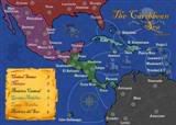 MIDDLE AMERICA MAP