Conquer Club

[Abandoned] - Croatia

Abandoned and Vacationed maps. The final resting place, unless you recycle.

Moderator: Cartographers

Forum rules
Please read the Community Guidelines before posting.

[Abandoned] - Croatia

Postby ivoK on Tue Jan 30, 2007 10:21 pm

map of Croatia

Image

Image
Last edited by ivoK on Mon Feb 12, 2007 4:45 pm, edited 5 times in total.
User avatar
Lieutenant ivoK
 
Posts: 129
Joined: Wed Dec 06, 2006 12:53 pm
Location: Toronto

Postby Lt.Mustard on Tue Jan 30, 2007 10:32 pm

looks like an interesting possibility. obviously a lot of graphics clean up will be needed, and the gameplay looks a little linear, although the sea routes do help. keep working on it, ivoK, and i think it could be a good map!
Okay, lecture's over - time for some Feedback!
User avatar
Cook Lt.Mustard
 
Posts: 86
Joined: Sat Nov 25, 2006 5:08 pm

Postby perchorin on Wed Jan 31, 2007 1:05 am

I like this idea, seems to have some good gameplay possibilities, keep working on it please!
User avatar
Major perchorin
 
Posts: 1859
Joined: Mon Sep 04, 2006 8:19 am
Location: Busan, South Korea

Postby gavin_sidhu on Wed Jan 31, 2007 2:33 am

I think you need to start again, ged rid of the straight borders between countries, i just wikied and found this map:

Image

from http://en.wikipedia.org/wiki/Counties_of_Croatia

You can use that map as a starting point. Also the picture in the background, is different to say the least, a person swimming in a lake, isn't theyre anything more croatian you could come up with?
User avatar
Lieutenant gavin_sidhu
 
Posts: 1428
Joined: Mon May 22, 2006 6:16 am
Location: Brisbane, Australia

Postby Balsiefen on Wed Jan 31, 2007 6:28 am

mabye add ports like philipines

Also you could add other countries in gray
User avatar
Sergeant 1st Class Balsiefen
 
Posts: 2299
Joined: Wed Aug 30, 2006 6:15 am
Location: The Ford of the Aldar in the East of the Kingdom of Lindissi

Postby Wisse on Wed Jan 31, 2007 6:31 am

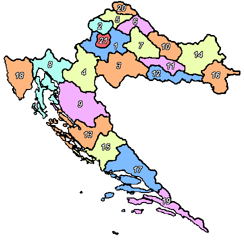
gavin_sidhu wrote:I think you need to start again, ged rid of the straight borders between countries, i just wikied and found this map:

Image

from http://en.wikipedia.org/wiki/Counties_of_Croatia

You can use that map as a starting point. Also the picture in the background, is different to say the least, a person swimming in a lake, isn't theyre anything more croatian you could come up with?

better idea i don't like your borders ;)
Image Image
User avatar
Sergeant Wisse
 
Posts: 4448
Joined: Fri Oct 13, 2006 2:59 pm
Location: The netherlands, gelderland, epe

Postby ivoK on Wed Jan 31, 2007 11:55 am

this is an extreme rough map. i mean, my gosh i threw it together in paint. im just wondering if there's an idea to be had. can anyone recommend a program for imaging? i know of the list on this forum but no one is really listed as better than another. what does everyone use here?
i tried unstraight borders and it just turned messy, but im working on one again.
User avatar
Lieutenant ivoK
 
Posts: 129
Joined: Wed Dec 06, 2006 12:53 pm
Location: Toronto

Postby Wisse on Wed Jan 31, 2007 12:04 pm

ivoK wrote:this is an extreme rough map. i mean, my gosh i threw it together in paint. im just wondering if there's an idea to be had. can anyone recommend a program for imaging? i know of the list on this forum but no one is really listed as better than another. what does everyone use here?
i tried unstraight borders and it just turned messy, but im working on one again.


the most use photoshop
Image Image
User avatar
Sergeant Wisse
 
Posts: 4448
Joined: Fri Oct 13, 2006 2:59 pm
Location: The netherlands, gelderland, epe

Postby gavin_sidhu on Wed Jan 31, 2007 9:57 pm

ivoK wrote:this is an extreme rough map. i mean, my gosh i threw it together in paint. im just wondering if there's an idea to be had. can anyone recommend a program for imaging? i know of the list on this forum but no one is really listed as better than another. what does everyone use here?
i tried unstraight borders and it just turned messy, but im working on one again.
Use the map above, get rid of all the colour and you will have the not straight borders without having to create them yourself.

Croatia isn't a very risk map friendly country, its too narrow and long, which you have attempted to fix using the far joining lines. Maybe you should make a map of the baltics, there has already been an attempt at that, and playability wise that was the map i was most looking forward to playing, it became abandoned when everyone started arguing about how big croatia should be, how big serbia should be and who was really the most evil.
User avatar
Lieutenant gavin_sidhu
 
Posts: 1428
Joined: Mon May 22, 2006 6:16 am
Location: Brisbane, Australia

Postby ivoK on Wed Jan 31, 2007 11:03 pm

gavin_sidhu wrote:
ivoK wrote:this is an extreme rough map. i mean, my gosh i threw it together in paint. im just wondering if there's an idea to be had. can anyone recommend a program for imaging? i know of the list on this forum but no one is really listed as better than another. what does everyone use here?
i tried unstraight borders and it just turned messy, but im working on one again.
Use the map above, get rid of all the colour and you will have the not straight borders without having to create them yourself.

Croatia isn't a very risk map friendly country, its too narrow and long, which you have attempted to fix using the far joining lines. Maybe you should make a map of the baltics, there has already been an attempt at that, and playability wise that was the map i was most looking forward to playing, it became abandoned when everyone started arguing about how big croatia should be, how big serbia should be and who was really the most evil.


word ur looking for is balkans. baltics is estonia, lithuania, and the others. i agree that croatia is not risk friendly because of its shape. ive tried several maps and came up with this. i can tell you who's evil but i dont wanna start up sh*t!
User avatar
Lieutenant ivoK
 
Posts: 129
Joined: Wed Dec 06, 2006 12:53 pm
Location: Toronto

Postby MarshmallowFluff on Thu Feb 01, 2007 1:22 am

I suppose I haven't played enough of the maps to really relate. Good I guess.
User avatar
Private MarshmallowFluff
 
Posts: 10
Joined: Tue Jan 30, 2007 5:28 pm

Postby ivoK on Mon Feb 12, 2007 4:47 pm

new version at the top
User avatar
Lieutenant ivoK
 
Posts: 129
Joined: Wed Dec 06, 2006 12:53 pm
Location: Toronto

Postby Dlakavi on Tue Feb 13, 2007 2:38 am

with your new update the map isn't the Croatia map any more.

But i think you have 2 options:
Image

OK, this map resembles Indochina map.

or you can have this:

Image

this would resemble the Ireland map.

Of course, the country lines would have to be adjusted
Image
User avatar
Lieutenant Dlakavi
 
Posts: 238
Joined: Wed Aug 23, 2006 7:45 am

Postby ivoK on Tue Feb 13, 2007 3:22 pm

obviously it's not croatia anymore, but i added bosna hercegovina to get rid of the linear gameplay
User avatar
Lieutenant ivoK
 
Posts: 129
Joined: Wed Dec 06, 2006 12:53 pm
Location: Toronto

Postby gavin_sidhu on Tue Feb 13, 2007 5:50 pm

MOst ppl find it easier if you post the latest map in a new post. I thought Bosnia and Herzegovina was usually split into sprska and bosnia herzegovnia.

Heres the thread for the other attempt at the map:

http://www.conquerclub.com/forum/viewto ... sc&start=0

check page 5.
Highest Score: 1843 Ranking (Australians): 3
User avatar
Lieutenant gavin_sidhu
 
Posts: 1428
Joined: Mon May 22, 2006 6:16 am
Location: Brisbane, Australia

Postby ivoK on Tue Feb 13, 2007 7:33 pm

RP is a political entity, not a recognized country or anything. krajina doesn't exist either.
User avatar
Lieutenant ivoK
 
Posts: 129
Joined: Wed Dec 06, 2006 12:53 pm
Location: Toronto

Postby ivoK on Tue Feb 13, 2007 7:34 pm

another version

Image
Last edited by ivoK on Wed Feb 14, 2007 5:33 pm, edited 1 time in total.
User avatar
Lieutenant ivoK
 
Posts: 129
Joined: Wed Dec 06, 2006 12:53 pm
Location: Toronto

Postby Wisse on Wed Feb 14, 2007 1:23 am

bad graphics
Image Image
User avatar
Sergeant Wisse
 
Posts: 4448
Joined: Fri Oct 13, 2006 2:59 pm
Location: The netherlands, gelderland, epe

Postby ivoK on Wed Feb 14, 2007 2:50 pm

of course the graphics are bad, especially the blue routes
User avatar
Lieutenant ivoK
 
Posts: 129
Joined: Wed Dec 06, 2006 12:53 pm
Location: Toronto

Postby Guiscard on Wed Feb 14, 2007 3:25 pm

What program are you using? I'd advise you to go back to the original map, trace the borders again, colour them nicely... Make it neat and simple then we can start commenting properly.
qwert wrote:Can i ask you something?What is porpose for you to open these Political topic in ConquerClub? Why you mix politic with Risk? Why you not open topic like HOT AND SEXY,or something like that.
User avatar
Private 1st Class Guiscard
 
Posts: 4103
Joined: Fri Dec 08, 2006 7:27 pm
Location: In the bar... With my head on the bar

Postby Wisse on Wed Feb 14, 2007 3:42 pm

ivoK wrote:of course the graphics are bad, especially the blue routes

no the borders and hills etc. are more worse
Image Image
User avatar
Sergeant Wisse
 
Posts: 4448
Joined: Fri Oct 13, 2006 2:59 pm
Location: The netherlands, gelderland, epe


Return to Recycling Box

Who is online

Users browsing this forum: No registered users