Two in the Main, Ruben? You've been busy lately!
As this is my first real look at this, I'm going to throw a lot at you - apologies if some of my comments have been covered.
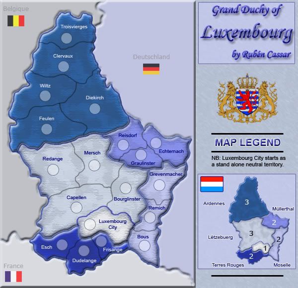
I have two issues with the beveling between the regions, which I see has already been questioned. The first is that some of the territory borders that collide with the region borders bleed over into the beveling while others do not. The second issue is that I think a bevel or shadow looks best when you're trying to give the impression that something is three dimensional, which is not what you are trying to do here. If the borders were river valleys the bevel would make perfect sense, otherwise not. Plus, to me they look like impassables.
Color scheme: makes me think that this is Luxembourg in an ice age, when really Lux' has a marine climate with warm summers and relatively mild winters. If you incorporated some red in the region colors, it would nicely mirror the colors of the flag.
Bonuses: correct me if I'm wrong, but on a small map I think you need to be extra careful with the bonuses. In a two or three player game (which you'll have a lot of on a small, quick map), whoever goes first will most likely be just one territory away from capturing a +3 bonus, which will mean the game is all but over after round two if the bonus holds. Doodle is wildly popular, and I think is a good example of solid bonus assignment on a smallmap. The only three territory region is a +2, while the +3 regions are four- and five territory regions with three borders each.
The presence of three easy to capture, +3 bonuses also makes the Luxembourg city bonus moot. Why waste armies hitting a neutral for a +1 when I can hit one enemy territory and obtain a +3 region? I'd drop all of the three territory regions down to a +2, max.
And why is everybody beveling around the outside of their maps these days? This, India, etc. Makes it look like the entire country has sunk, which would be fine if this was a Holland map.